| View all NH 4,000 Footers |
| Mount Adams |
| Mount Bond |
| Bondcliff |
| Mount Bond, West Peak |
| Mount Cabot |
| Cannon Mountain |
| Mount Carrigain |
| Carter Dome |
| Carter, Middle |
| Carter, South |
| Mount Eisenhower |
| Mount Field |
| Mount Flume |
| Mount Galehead |
| Mount Garfield |
| Mount Hale |
| Mount Hancock |
| Mount Hancock, South Peak |
| Mount Isolation |
| Mount Jackson |
| Mount Jefferson |
| Mount Kinsman, North Peak |
| Mount Kinsman, South Peak |
| Mount Lafayette |
| Mount Liberty |
| Mount Lincoln |
| Mount Madison |
| Mount Monroe |
| Mount Moosilauke |
| Mount Moriah |
| Mount Osceola |
| Mount Osceola, East Peak |
| Owl's Head |
| Mount Passaconway |
| Mount Pierce |
| Mount Tecumseh |
| Mount Tom |
| Mount Tripyramid, Middle Peak |
| Mount Tripyramid, North Peak |
| Mount Twin, North Peak |
| Mount Twin, South Peak |
| Mount Washington |
| Mount Waumbek |
| Mount Whiteface |
| Mount Wildcat, A Peak |
| Mount Wildcat, D Peak |
| Mount Willey |
| Zealand Mountain |
| NH Mountain Ranges/ Areas ↓ |
| View all NH Mountain Ranges |
| Baldface-Royce Range |
| Carter-Moriah Range |
| Dartmouth Range |
| Franconia Range |
| Kinsman Range |
| Mahoosuc Range |
| Northern Ranges |
| Ossipee Mountains |
| Pemigewasset Wilderness |
| Pilot Range |
| Pliny Range |
| Presidential Range |
| Sandwich Range |
| Twin Range |
| Wapack Range |
| Willey Range |
|
|
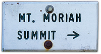
Hike Mount Moriah |
| |
| On this page: Information | Trail maps | View Photos | Driving Directions |
| |
Elevation: 4,049 feet (1,234 meters)
Prominence:  922 feet (281 meters) 922 feet (281 meters)
Location: Gorham, NH, Coös County
Range: Carter-Moriah Range
Coordinates: 44°20'25" North 71°07'53" West
Rating: Easy / Moderate
Features: Mount Surprise, 360°summit views
Distance of highlighted hike below: 9 miles
|
 |
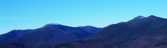
Mount Moriah's summit is 4,049 feet and is located 5 miles Southeast of Gorham, NH. It is part of the Carter-Moriah Range in the White Mountains. The shortest route up to the summit is up the Carter-Moriah trail, which goes over Mount Surprise (2,194') before reaching Mount Moriah. The trail is relatively easy, compared to other NH 4,000 footer mountains, but, it can be very dangerous when wet, because a big portion of the Carter-Moriah trail is solid rock. (very slippery when wet, or icy!)
|
|
 |
| |
| The summit of Mount Moriah is bare rock above tree line, offering incredible views on a clear day with 360° views of the Presidential Range and the rest of the Carter-Moriah Range. |
| For peak-baggers: |
Mount Surprise is 2.5 miles from the summit of Mount Moriah
Shelburne Moriah Mountain is 2.7 miles from the summit of Mount Moriah
North Carter Mountain is 3.7 miles from the summit of Mount Moriah
Middle Carter Mountain is 4.5 miles from the summit of Mount Moriah
|
|
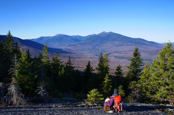
Views from Mount Surprise on the way up to Mount Moriah on October 24, 2012.
|
| |
| Mount Moriah Trail Maps - Directions from the parking lot to the summit |
Top |
The trail map below shows how to get to the summit of Mount Moriah and Mount Surprise via the Carter-Moriah Trail.
Starting at the Carter-Moriah trail head, hike up the Carter-Moriah Trail for 2 miles until you reach the summit of Mount Surprise where you can enjoy great views! After you are done soaking in the views, continue up the Carter-Moriah Trail for 2.5 miles where you will reach the summit of Mount Moriah. Here you can enjoy 360 degree mountain views on a clear day.
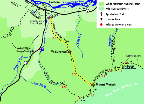
Click to download PDF Trail Map of Mount Moriah
|
| |
| |
|
Views of Mount Washington and the Presidential Range from Mount Moriah on October 24, 2011.
|
| Mount Moriah Driving Directions |
Top |
The parking lot for the highlighted hike above can be tricky to find. It is located at the end of Bangor Street in Gorham, NH. There is no actual parking lot at the trail head, so you can either park on the street if there is room, or park in the parking lot at the end of Promenade Street, roughly 0.8 miles away. (You will walk along the road, and cross over a suspension bridge before you reach Bangor Street, where the Carter-Moriah Trail starts.
 |
|
Directions to Bangor Street (Carter-Moriah Trail head) from the South:
Take exit 35 off I-93 to US-3 N towards Twin Mountain / Lancaster. Drive 12.3 miles and turn right onto NH-115 N. Drive 9.6 miles and turn right onto US-2 E. Continue 12.5 miles on Route 2 and turn right onto Main Street. Drive 1.9 miles and turn right on Bangor Street. The trail begins at the end of the road. (no parking at the trail head) |
| |
Directions to the parking lot on Promenade Street from the South:
Take exit 35 off I-93 to US-3 N towards Twin Mountain / Lancaster. Drive 12.3 miles and turn right onto NH-115 N. Drive 9.6 miles and turn right onto US-2 E/Presidential Hwy. Continue 12.5 miles on Route 2 and turn right onto Main Street. Drive 1 mile and turn right on Church Street. Drive 0.2 miles then turn right on Promenade Street. The parking lot is at the end of the road. |
|
On this page: Information | Trail maps | View Photos | Driving Directions | Top
|
|
|
|
|
|
|
|
|
|
|
|
|
|
|
| |
| |
|
| New Hampshire 4,000 Footers |
Vermont + Maine 4,000 Footers |
Other Hiking Lists / Patches |
New England Mountain Ranges |
Stay Involved in New England |
New Hampshire
Mount Adams
Mount Bond
Bondcliff
Mount Bond, West Peak
Mount Cabot
Cannon Mountain
Mount Carrigain
Carter Dome
Carter, Middle
Carter, South
Mount Eisenhower
Mount Field
Mount Flume
Mount Galehead
Mount Garfield
Mount Hale
Mount Hancock
Mount Hancock, South Peak
Mount Isolation
Mount Jackson
Mount Jefferson
Mount Kinsman, North Peak
Mount Kinsman, South Peak
Mount Lafayette
Mount Liberty
Mount Lincoln
Mount Madison
Mount Monroe
Mount Moosilauke
Mount Moriah
Mount Osceola
Mount Osceola, East Peak
Owl's Head
Mount Passaconway
Mount Pierce
Mount Tecumseh
Mount Tom
Mount Tripyramid, Middle Peak
Mount Tripyramid, North Peak
Mount Twin, North Peak
Mount Twin, South Peak
Mount Washington
Mount Waumbek
Mount Whiteface
Mount Wildcat, A Peak
Mount Wildcat, D Peak
Mount Willey
Zealand Mountain |
Vermont
Mount Abraham
Camel's Hump
Mount Ellen
Killington Peak
Mount Mansfield
Maine
Mount Abraham
Mount Bigelow, Avery Peak
Mount Bigelow, West Peak
Crocker Mountain
Crocker Mountain, South
Mount Katahdin, Baxter Peak
Mount Katahdin, Hamlin Peak
North Brother Mountain
Old Speck Mountain
Mount Redington
Saddleback Mountain
Saddleback Mountain, The Horn
Spaulding Mountain
Sugarloaf Mountain |
NH 4,000 footers
NH 4,000 footers in Winter
New England 4,000 footers
NE 4,000 footers in Winter
NH Hundred Highest
New England Fifty Finest
52 With a view
Trailwrights 72 summit club
New England Hundred highest
NE Hundred highest in Winter
Northeast 111
48x12 "The Grid"
Red Lining
Belknap Range
LRCT / Castle in the Clouds
NH Fire Tower Quest
Hike by - Alphabetically
Hike by - Elevation
Hike by - Prominence
Hike by - Mountain Range |
Ranges in New Hampshire
View all NH mountain ranges
Baldface-Royce Range
Carter-Moriah Range
Dartmouth Range
Franconia Range
Kinsman Range
Mahoosuc
Range
Ossipee Mountains
Northern Ranges
Pemigewasset Wilderness
Pilot Range
Pliny Range
Presidential Range
Sandwich Range
Twin Range
Wapack Range
Western White Mountains
Willey Range
Ranges in Maine
View all ME mountain ranges
Baxter State Park
High Peaks
Bigelow Range
Eastern White Mountains
Ranges in Vermont
Green Mountains
Other VT mountain ranges |
NH Waterfalls
NH AMC Huts
Hiker's store |
New England 4,000 Footers | NH 4,000 Footers | VT 4,000 Footers | ME 4,000 Footers | Hiking Lists & Patches | Hiker's Store | Contact by email
© www.4000footers.com 2015. All rights reserved. We are not affiliated with the AMC or the AMC Four Thousand Footer Club |
|
|