| 52 with a View List ↓ |
| Mount Avalon |
| Baldface, North |
| Baldface, South |
| Black Mountain, (Benton) |
| Black Mountain, Middle (Jackson) |
| Blueberry Mountain |
| Mount Cardigan |
| Mount Chocorua |
| Mount Crawford |
| Mount Cube |
| Doublehead, North |
| Eagle Crag (Mt. Meader) |
| Eastman Mountain |
| Mount Hayes |
| Hedgehog Mountain |
| Mount Hibbard |
| Horn, The |
| Imp Face |
| Iorn Mountain |
| Mount Israel |
| Jennings Peak |
| Mount Kearsarge |
| Kearsarge North |
| Magalloway Mountain |
| Mount Martha (Cherry / Owls Head) |
| Moat Mountain, North |
| Moat Mountain, South |
| Mount Monadnock |
| Mount Parker |
| Mount Paugus |
| Mount Pemigewasset |
| Percy Peaks, North Peak |
| Potash Mountain |
| Mount Resolution |
| Mount Roberts |
| Royce Mountain, West |
| Sandwich Dome |
| Mount Shaw |
| Shelburne Moriah Mountain |
| Sisters, Middle |
| Smarts Mountain |
| Square Ledge |
| Stairs Mountain |
| Mount Starr King |
| Stinson Mountain |
| Mount Success |
| Sugarloaf Mountain |
| Sugarloaf Mountain, Middle |
| Mount Tremont |
| Mount Webster |
| Welch / Dickey Mountain |
| Mount Willard |
|
|
Hike Mount Cardigan |
| |
| On this page: Information | Trail maps | View Photos | Driving Directions |
| |
| Mount Cardigan Information |
Elevation: 3,155 feet (962 meters)
Prominence:  1,925 feet (587 meters) 1,925 feet (587 meters)
Location: Orange, NH (Lakes Region, NH)
Coordinates: 43°38'59" North 71°54'53" West
Features: 360° summit views, summit tower, Cardigan Mountain State Forest
Distance of highlighted hike below: 3 miles
|
 |
Mount Cardigan is a mountain located in Cardigan Mountain State Forest in the Lakes Region of New Hampshire in the town of Orange. Although the elevation is only 3,155 feet, it gives hikers a feeling they are much higher due to the huge areas of bare granite rock with some alpine growth. The summit has a fire tower and amazing 360° views.
There is a lodge called the Cardigan Lodge which has been operated by the AMC since 1934, located to the East at the foot of the mountain.
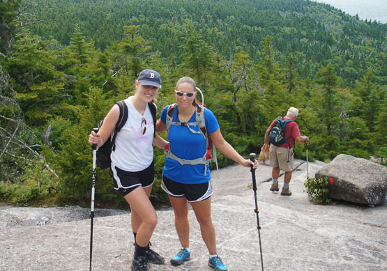
The easiest route up to the summit of Mt .Cardigan is the West Ridge Trail which goes directly to the summit in 1.5 miles.
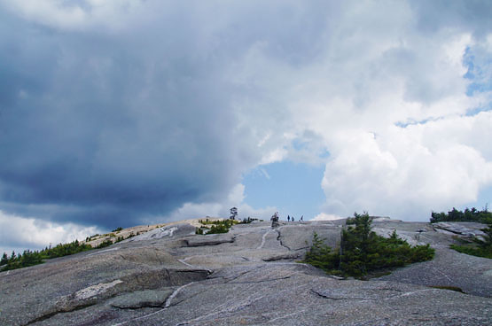
Almost at the summit of Mount Cardigan from the West Ridge Trail on August 11, 2014.
|
| Mount Cardigan Trail Maps |
Top |
The map below shows how to get to the summit of Mount Cardigan.
From the parking lot, the West Ridge Trail starts just behind the shelter. Hike on the West Ridge Trail for 1.5 miles until you reach the summit of Mount Cardigan. (You will pass a junction with the South Ridge Trail and a trail to Rimrock before reaching the summit.) Note the last roughly half mile of this trail is all open rock slabs, so if it is wet or icy, please plan accordingly.
To get back to the parking lot, retrace your steps the same way you came up.
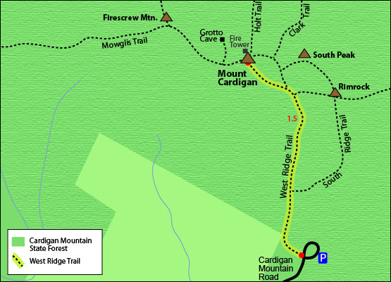
Click to download PDF Trail Map of Mount Cardigan.
|
| |
| Mount Cardigan Photos |
Top |
|
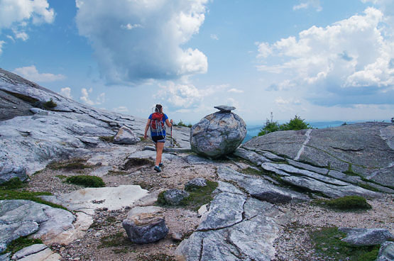
"Meatball Rock" near the summit of Mount Cardigan on August 11, 2014.
Hiking up the West Ridge Trail to Mount Cardigan on August 11, 2014.
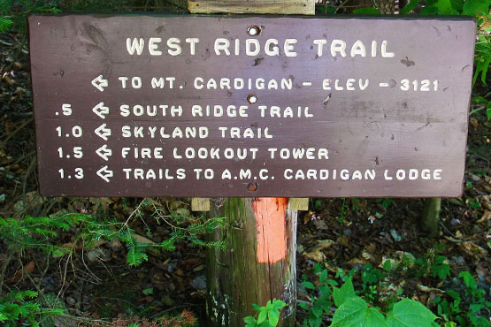
West Ridge Trail sign from the parking lot on August 11, 2014.
|
| Mount Cardigan Driving Directions |
Top |
These are driving directions to the West Ridge Trail parking area
Take exit 17 from I-93 North to get on Route 4 West. Turn right onto Route 4 West / Hoit Road. Drive 1.2 miles and continue straight through the traffic circle to stay on Route 4 West. Drive 2.5 miles and turn slight left to stay on Route 4 West. Drive 15.2 miles and turn right to stay on Route 4 West. Drive 20.9 miles and turn sharply right onto Parker Street / Route 118. Drive 0.6 miles and turn right onto Cardigan Mountain Road. When you get the Burnt Hill Road, turn left to stay on Cardigan Mountain Road. (You will see a Cardigan Mountain State Forest sign here) Drive until you come to the parking lot.
If you have a GPS, you can put in Cardigan Mountain Road in Orange, NH and look for the parking area on the road.
|
|
On this page: Information | Trail maps | View Photos | Driving Directions | Top
|
|
|
|
|
|
|
|
|
|
| |
|
|
|
| |
| New Hampshire 4,000 Footers |
Vermont + Maine 4,000 Footers |
Other Hiking Lists / Patches |
New England Mountain Ranges |
Stay Involved in New England |
New Hampshire
Mount Adams
Mount Bond
Bondcliff
Mount Bond, West Peak
Mount Cabot
Cannon Mountain
Mount Carrigain
Carter Dome
Carter, Middle
Carter, South
Mount Eisenhower
Mount Field
Mount Flume
Mount Galehead
Mount Garfield
Mount Hale
Mount Hancock
Mount Hancock, South Peak
Mount Isolation
Mount Jackson
Mount Jefferson
Mount Kinsman, North Peak
Mount Kinsman, South Peak
Mount Lafayette
Mount Liberty
Mount Lincoln
Mount Madison
Mount Monroe
Mount Moosilauke
Mount Moriah
Mount Osceola
Mount Osceola, East Peak
Owl's Head
Mount Passaconway
Mount Pierce
Mount Tecumseh
Mount Tom
Mount Tripyramid, Middle Peak
Mount Tripyramid, North Peak
Mount Twin, North Peak
Mount Twin, South Peak
Mount Washington
Mount Waumbek
Mount Whiteface
Mount Wildcat, A Peak
Mount Wildcat, D Peak
Mount Willey
Zealand Mountain |
Vermont
Mount Abraham
Camel's Hump
Mount Ellen
Killington Peak
Mount Mansfield
Maine
Mount Abraham
Mount Bigelow, Avery Peak
Mount Bigelow, West Peak
Crocker Mountain
Crocker Mountain, South
Mount Katahdin, Baxter Peak
Mount Katahdin, Hamlin Peak
North Brother Mountain
Old Speck Mountain
Mount Redington
Saddleback Mountain
Saddleback Mountain, The Horn
Spaulding Mountain
Sugarloaf Mountain |
NH 4,000 footers
NH 4,000 footers in Winter
New England 4,000 footers
NE 4,000 footers in Winter
NH Hundred Highest
New England Fifty Finest
52 With a view
Trailwrights 72 summit club
New England Hundred highest
NE Hundred highest in Winter
Northeast 111
48x12 "The Grid"
Red Lining
Belknap Range
LRCT / Castle in the Clouds
NH Fire Tower Quest
Hike by - Alphabetically
Hike by - Elevation
Hike by - Prominence
Hike by - Mountain Range |
Ranges in New Hampshire
View all NH mountain ranges
Baldface-Royce Range
Carter-Moriah Range
Dartmouth Range
Franconia Range
Kinsman Range
Mahoosuc
Range
Ossipee Mountains
Northern Ranges
Pemigewasset Wilderness
Pilot Range
Pliny Range
Presidential Range
Sandwich Range
Twin Range
Wapack Range
Western White Mountains
Willey Range
Ranges in Maine
View all ME mountain ranges
Baxter State Park
High Peaks
Bigelow Range
Eastern White Mountains
Ranges in Vermont
Green Mountains
Other VT mountain ranges |
NH Waterfalls
NH AMC Huts
Hiker's store |
New England 4,000 Footers | NH 4,000 Footers | VT 4,000 Footers | ME 4,000 Footers | Hiking Lists & Patches | Hiker's Store | Contact by email
© www.4000footers.com 2015. All rights reserved. We are not affiliated with the AMC or the AMC Four Thousand Footer Club |
|
|