| 52 with a View List ↓ |
| Mount Avalon |
| Baldface, North |
| Baldface, South |
| Black Mountain, (Benton) |
| Black Mountain, Middle (Jackson) |
| Blueberry Mountain |
| Mount Cardigan |
| Mount Chocorua |
| Mount Crawford |
| Mount Cube |
| Doublehead, North |
| Eagle Crag (Mt. Meader) |
| Eastman Mountain |
| Mount Hayes |
| Hedgehog Mountain |
| Mount Hibbard |
| Horn, The |
| Imp Face |
| Iorn Mountain |
| Mount Israel |
| Jennings Peak |
| Mount Kearsarge |
| Kearsarge North |
| Magalloway Mountain |
| Mount Martha (Cherry / Owls Head) |
| Moat Mountain, North |
| Moat Mountain, South |
| Mount Monadnock |
| Mount Parker |
| Mount Paugus |
| Mount Pemigewasset |
| Percy Peaks, North Peak |
| Potash Mountain |
| Mount Resolution |
| Mount Roberts |
| Royce Mountain, West |
| Sandwich Dome |
| Mount Shaw |
| Shelburne Moriah Mountain |
| Sisters, Middle |
| Smarts Mountain |
| Square Ledge |
| Stairs Mountain |
| Mount Starr King |
| Stinson Mountain |
| Mount Success |
| Sugarloaf Mountain |
| Sugarloaf Mountain, Middle |
| Mount Tremont |
| Mount Webster |
| Welch / Dickey Mountain |
| Mount Willard |
|
|
Hike Mount Pemigewasset (Indian Head) |
| |
| On this page: Information | Trail maps | View Photos | Driving Directions |
| |
| Mount Pemigewasset Information |
Elevation: 2,557 feet (779 meters)
Location: Lincoln, NH (Grafton County)
Coordinates: 44°5'52" North 71°41'59" West
Features: Great summit views, rock slab summit, no river crossings
Distance of highlighted hike below: 3.4 miles
|
 |
Mount Pemigewasset is a 2,557 foot mountain located in Lincoln, NH right off I-93. It is also known as Indian Head. The mountain is on the 52 with a view hiking list, because it is under 4,000 feet in elevation and offeres incredible views from the bare open summit.
The easiest route to the summit is via the Mount Pemigewasset Trail from the Flume Visitor Center parking lot.
Be sure to check out other areas of interest near Mount Pemigewasset that include: The Basin, Harvard & Georgiana Falls.
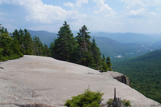
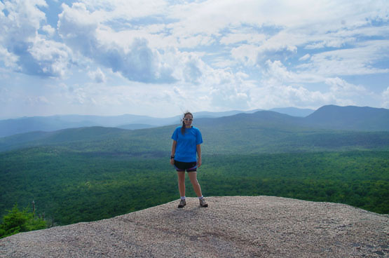
Summit of Mount Pemigewasset / Indian Head on August 5, 2014.
|
| Mount Pemigewasset Trail Maps |
Top |
The map below shows how to get to the summit of Mount Pemigewasset Indian Head.
From the Flume Visitor Center parking lot, the trail begins in the furthest parking area from the enterance. Look for signs for the bike path, which goes uphill right from the parking lot. To find the start of the trail, walk up the paved hill for about a minute and you will see a sign on the left to begin the Mt. Pemigewasset trail. From there, hike for 1.5 miles until you reach the summit. (at the 1.4 mile mark, you will come to a junction with the Indian Head Trail on the right. Stay left to continue to the summit of Mount Pemigewasset.)
To get back to the parking lot, retrace your steps the same way you came up.
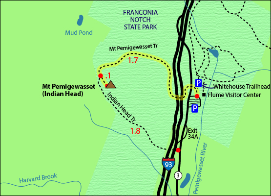
Click to download PDF Trail Map of Mount Pemigewasset.
|
| |
| Mount Pemigewasset Photos |
Top |
|
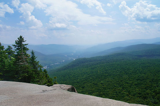
Summit of Mount Pemigewasset / Indian Head on August 5, 2014.
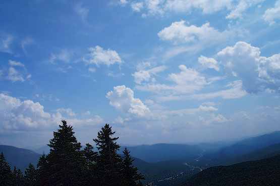
Views from the summit of Mount Pemigewasset looking down on Franconia Notch on August 5, 2014.
Summit of Mount Pemigewasset / Indian Head on August 5, 2014.
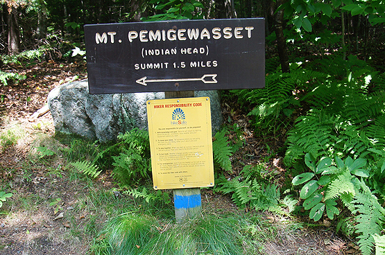
Trail sign at the beginning of the Mt.Pemigewasset trail on August 5, 2014.
|
| Mount Pemigewasset Driving Directions |
Top |
These are driving directions to the Flume Visitor Center parking lot where the trail starts
Take exit 34a from I-93 North to get onto US 3 North towards the Flume Gorge / Park Information Center. Drive 0.4 miles and turn right into the Flume parking area. The Pemigewasset Trail to get to the summit starts in the last parking lot all the way to the left. (Look for signs for the bike path, which goes uphill right from the parking lot. To find the start of the trail, walk up the paved hill for about a minute and you will see a sign on the left to begin the Mt. Pemigewasset trail).
|
|
On this page: Information | Trail maps | View Photos | Driving Directions | Top
|
|
|
|
|
|
|
|
|
|
| |
|
|
|
| |
| New Hampshire 4,000 Footers |
Vermont + Maine 4,000 Footers |
Other Hiking Lists / Patches |
New England Mountain Ranges |
Stay Involved in New England |
New Hampshire
Mount Adams
Mount Bond
Bondcliff
Mount Bond, West Peak
Mount Cabot
Cannon Mountain
Mount Carrigain
Carter Dome
Carter, Middle
Carter, South
Mount Eisenhower
Mount Field
Mount Flume
Mount Galehead
Mount Garfield
Mount Hale
Mount Hancock
Mount Hancock, South Peak
Mount Isolation
Mount Jackson
Mount Jefferson
Mount Kinsman, North Peak
Mount Kinsman, South Peak
Mount Lafayette
Mount Liberty
Mount Lincoln
Mount Madison
Mount Monroe
Mount Moosilauke
Mount Moriah
Mount Osceola
Mount Osceola, East Peak
Owl's Head
Mount Passaconway
Mount Pierce
Mount Tecumseh
Mount Tom
Mount Tripyramid, Middle Peak
Mount Tripyramid, North Peak
Mount Twin, North Peak
Mount Twin, South Peak
Mount Washington
Mount Waumbek
Mount Whiteface
Mount Wildcat, A Peak
Mount Wildcat, D Peak
Mount Willey
Zealand Mountain |
Vermont
Mount Abraham
Camel's Hump
Mount Ellen
Killington Peak
Mount Mansfield
Maine
Mount Abraham
Mount Bigelow, Avery Peak
Mount Bigelow, West Peak
Crocker Mountain
Crocker Mountain, South
Mount Katahdin, Baxter Peak
Mount Katahdin, Hamlin Peak
North Brother Mountain
Old Speck Mountain
Mount Redington
Saddleback Mountain
Saddleback Mountain, The Horn
Spaulding Mountain
Sugarloaf Mountain |
NH 4,000 footers
NH 4,000 footers in Winter
New England 4,000 footers
NE 4,000 footers in Winter
NH Hundred Highest
New England Fifty Finest
52 With a view
Trailwrights 72 summit club
New England Hundred highest
NE Hundred highest in Winter
Northeast 111
48x12 "The Grid"
Red Lining
Belknap Range
LRCT / Castle in the Clouds
NH Fire Tower Quest
Hike by - Alphabetically
Hike by - Elevation
Hike by - Prominence
Hike by - Mountain Range |
Ranges in New Hampshire
View all NH mountain ranges
Baldface-Royce Range
Carter-Moriah Range
Dartmouth Range
Franconia Range
Kinsman Range
Mahoosuc
Range
Ossipee Mountains
Northern Ranges
Pemigewasset Wilderness
Pilot Range
Pliny Range
Presidential Range
Sandwich Range
Twin Range
Wapack Range
Western White Mountains
Willey Range
Ranges in Maine
View all ME mountain ranges
Baxter State Park
High Peaks
Bigelow Range
Eastern White Mountains
Ranges in Vermont
Green Mountains
Other VT mountain ranges |
NH Waterfalls
NH AMC Huts
Hiker's store |
New England 4,000 Footers | NH 4,000 Footers | VT 4,000 Footers | ME 4,000 Footers | Hiking Lists & Patches | Hiker's Store | Contact by email
© www.4000footers.com 2015. All rights reserved. We are not affiliated with the AMC or the AMC Four Thousand Footer Club |
|
|