| 52 with a View List ↓ |
| Mount Avalon |
| Baldface, North |
| Baldface, South |
| Black Mountain, (Benton) |
| Black Mountain, Middle (Jackson) |
| Blueberry Mountain |
| Mount Cardigan |
| Mount Chocorua |
| Mount Crawford |
| Mount Cube |
| Doublehead, North |
| Eagle Crag (Mt. Meader) |
| Eastman Mountain |
| Mount Hayes |
| Hedgehog Mountain |
| Mount Hibbard |
| Horn, The |
| Imp Face |
| Iorn Mountain |
| Mount Israel |
| Jennings Peak |
| Mount Kearsarge |
| Kearsarge North |
| Magalloway Mountain |
| Mount Martha (Cherry / Owls Head) |
| Moat Mountain, North |
| Moat Mountain, South |
| Mount Monadnock |
| Mount Parker |
| Mount Paugus |
| Mount Pemigewasset |
| Percy Peaks, North Peak |
| Potash Mountain |
| Mount Resolution |
| Mount Roberts |
| Royce Mountain, West |
| Sandwich Dome |
| Mount Shaw |
| Shelburne Moriah Mountain |
| Sisters, Middle |
| Smarts Mountain |
| Square Ledge |
| Stairs Mountain |
| Mount Starr King |
| Stinson Mountain |
| Mount Success |
| Sugarloaf Mountain |
| Sugarloaf Mountain, Middle |
| Mount Tremont |
| Mount Webster |
| Welch / Dickey Mountain |
| Mount Willard |
|
|
Hike Mount Israel |
| |
| On this page: Information | Trail maps | View Photos | Driving Directions |
| |
Elevation: 2,620 feet (799 meters)
Location: Center Sandwich, NH
Rating:  Moderate (Roughly 1,900 feet of elevation gain) Moderate (Roughly 1,900 feet of elevation gain)
Features: Bare rock summit with views, 52 with a View, no major river crossings, some rock scrambling near the summit
Distance of highlighted hike below: 4 miles via the Wentworth Trail.
|
 |
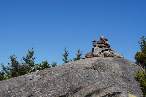
Mount Israel is a 2,620 foot mountain in the Waterville Valley-Sandwich Range near the Lakes Region of New Hampshire. The summit and view point near the summit off the Wentworth Trail offer spectacular views of the Sandwich Range and Mount Chocorua. There was once a fire tower on the summit.
The most popular route up is via the Wentworth Trail. You can also hike up via the Guinea Pond Trail and the Mead Trail.
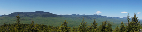
Photo taken from the summit of Mount Israel on 5-23-2015.
|
| Mount Israel Trail Maps |
Top |
The map below shows how to get to the summit of Mount Israel via the Wentworth Trail.
From the parking lot, the Wentworth Trail starts behind the white house to the left. There is a slight dirt path leading up that way. See photo below. Follow the Wentworth Trail for 2 miles until you reach the summit! To get back down to the parking lot, retrace your steps down the Wentworth Trail for 2 miles.
Note: There is a false summit on this hike, so when you reach a high point that looks like it could be the summit, look to the right and you will see the true summit is just a bit higher and over to the right. The trail will go down then back up to it. The true summit has a cairn.
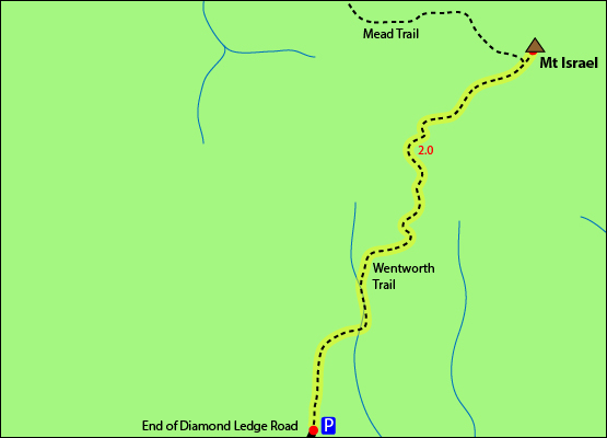
Click to download PDF Trail Map of Mount Israel
|
| |
|
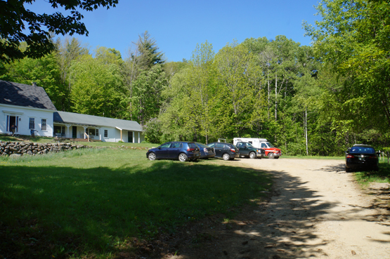
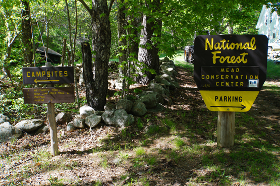
Photo taken from the parking lot for the Wentworth Trail on 5-23-2015.
Trailhead for the Wentworth Trail on 5-23-2015.
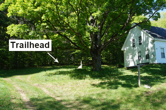
The Wentworth trailhead can be hard to see from the parking lot, but it is to the left of the white house where the arrow is pointing.
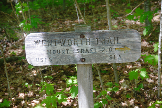
Wentworth Trail sign on 5-23-2015.
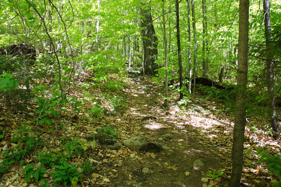
Wentworth Trail on the way up to Mount Israel on 5-23-2015.
Summit of Mount Israel! Taken
on 5-23-2015.
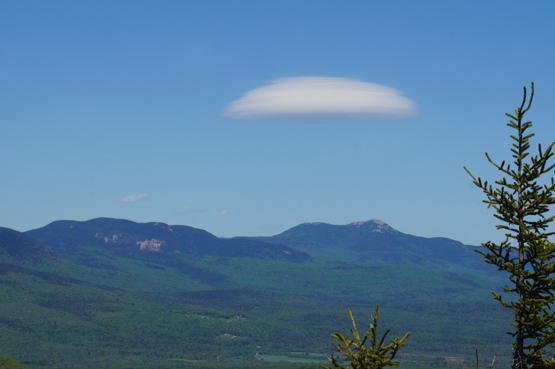
Photo taken from the summit of Mount Israel on 5-23-2015.
|
| Mount Israel Driving Directions |
Top |
These are driving directions to the Wentworth Trail Trailhead Parking lot:
From I-93 North, take exit 24. Turn right onto Route 25 East. Drive 4.5 miles Turn left onto Route 113. Drive 11.6 miles and take a sharp left onto Grove Street. Stay on this road which turns into Diamond Ledge Road until you come to the end, which is roughly 2.8 miles. There is a big white house and the parking lot is on the right.
|
|
On this page: Information | Trail maps | View Photos | Driving Directions | Top
|
|
|
|
|
|
|
|
|
|
| |
|
|
|
| |
| New Hampshire 4,000 Footers |
Vermont + Maine 4,000 Footers |
Other Hiking Lists / Patches |
New England Mountain Ranges |
Stay Involved in New England |
New Hampshire
Mount Adams
Mount Bond
Bondcliff
Mount Bond, West Peak
Mount Cabot
Cannon Mountain
Mount Carrigain
Carter Dome
Carter, Middle
Carter, South
Mount Eisenhower
Mount Field
Mount Flume
Mount Galehead
Mount Garfield
Mount Hale
Mount Hancock
Mount Hancock, South Peak
Mount Isolation
Mount Jackson
Mount Jefferson
Mount Kinsman, North Peak
Mount Kinsman, South Peak
Mount Lafayette
Mount Liberty
Mount Lincoln
Mount Madison
Mount Monroe
Mount Moosilauke
Mount Moriah
Mount Osceola
Mount Osceola, East Peak
Owl's Head
Mount Passaconway
Mount Pierce
Mount Tecumseh
Mount Tom
Mount Tripyramid, Middle Peak
Mount Tripyramid, North Peak
Mount Twin, North Peak
Mount Twin, South Peak
Mount Washington
Mount Waumbek
Mount Whiteface
Mount Wildcat, A Peak
Mount Wildcat, D Peak
Mount Willey
Zealand Mountain |
Vermont
Mount Abraham
Camel's Hump
Mount Ellen
Killington Peak
Mount Mansfield
Maine
Mount Abraham
Mount Bigelow, Avery Peak
Mount Bigelow, West Peak
Crocker Mountain
Crocker Mountain, South
Mount Katahdin, Baxter Peak
Mount Katahdin, Hamlin Peak
North Brother Mountain
Old Speck Mountain
Mount Redington
Saddleback Mountain
Saddleback Mountain, The Horn
Spaulding Mountain
Sugarloaf Mountain |
NH 4,000 footers
NH 4,000 footers in Winter
New England 4,000 footers
NE 4,000 footers in Winter
NH Hundred Highest
New England Fifty Finest
52 With a view
Trailwrights 72 summit club
New England Hundred highest
NE Hundred highest in Winter
Northeast 111
48x12 "The Grid"
Red Lining
Belknap Range
LRCT / Castle in the Clouds
NH Fire Tower Quest
Hike by - Alphabetically
Hike by - Elevation
Hike by - Prominence
Hike by - Mountain Range |
Ranges in New Hampshire
View all NH mountain ranges
Baldface-Royce Range
Carter-Moriah Range
Dartmouth Range
Franconia Range
Kinsman Range
Mahoosuc
Range
Ossipee Mountains
Northern Ranges
Pemigewasset Wilderness
Pilot Range
Pliny Range
Presidential Range
Sandwich Range
Twin Range
Wapack Range
Western White Mountains
Willey Range
Ranges in Maine
View all ME mountain ranges
Baxter State Park
High Peaks
Bigelow Range
Eastern White Mountains
Ranges in Vermont
Green Mountains
Other VT mountain ranges |
NH Waterfalls
NH AMC Huts
Hiker's store |
New England 4,000 Footers | NH 4,000 Footers | VT 4,000 Footers | ME 4,000 Footers | Hiking Lists & Patches | Hiker's Store | Contact by email
© www.4000footers.com 2015. All rights reserved. We are not affiliated with the AMC or the AMC Four Thousand Footer Club |
|
|