| 52 with a View List ↓ |
| Mount Avalon |
| Baldface, North |
| Baldface, South |
| Black Mountain, (Benton) |
| Black Mountain, Middle (Jackson) |
| Blueberry Mountain |
| Mount Cardigan |
| Mount Chocorua |
| Mount Crawford |
| Mount Cube |
| Doublehead, North |
| Eagle Crag (Mt. Meader) |
| Eastman Mountain |
| Mount Hayes |
| Hedgehog Mountain |
| Mount Hibbard |
| Horn, The |
| Imp Face |
| Iorn Mountain |
| Mount Israel |
| Jennings Peak |
| Mount Kearsarge |
| Kearsarge North |
| Magalloway Mountain |
| Mount Martha (Cherry / Owls Head) |
| Moat Mountain, North |
| Moat Mountain, South |
| Mount Monadnock |
| Mount Parker |
| Mount Paugus |
| Mount Pemigewasset |
| Percy Peaks, North Peak |
| Potash Mountain |
| Mount Resolution |
| Mount Roberts |
| Royce Mountain, West |
| Sandwich Dome |
| Mount Shaw |
| Shelburne Moriah Mountain |
| Sisters, Middle |
| Smarts Mountain |
| Square Ledge |
| Stairs Mountain |
| Mount Starr King |
| Stinson Mountain |
| Mount Success |
| Sugarloaf Mountain |
| Sugarloaf Mountain, Middle |
| Mount Tremont |
| Mount Webster |
| Welch / Dickey Mountain |
| Mount Willard |
|
|
Hike Mount Roberts |
| |
| On this page: Information | Trail maps | View Photos | Driving Directions |
| |
| Mount Roberts Information |
Elevation: 2,582 feet (787 meters)
Location: Moultonborough, NH
Range: Ossipee
Range
Features: Lakes Region Conservation Trust (Castle in the Clouds), summit views, 52 with a View
Coordinates: 43.7565°N 71.3265°W
Distance of highlighted hike below: 5 miles
|
 |
Mount Roberts is a 2,582 foot mountain in Moultonborough, NH. It is on the Lakes Region Conservation Trust property, also known as the Castle in the Clouds estate. It is part of the Ossipee
Range.
Mount Roberts is on the 52 with a View hiking list as well as the Lakes Region Conservation Trust (Castle in the Clouds).
|
| Mount Roberts Trail Maps |
Top |
The map below shows how to get to the summit of Mount Roberts.
From the Upper Trailhead Kiosk off Ossipee Park Road in Moultonborough, NH, walk towards Shannon Pond and follow the left fork of the paved road toward the barn with the red roof. Keeping the barn to your left, head for the corner of the fenced-in-field where it almost meets the woods. At that corner, you will find the trailhead for the Mt. Roberts trail. It follows Roberts Ridge for 2.5 miles to the summit of Mount Roberts, often across open ledges that provide incredible views towards Lake Winnipesaukee. To get back to the parking area, retrace your steps back down.
Click the map below for a larger version.
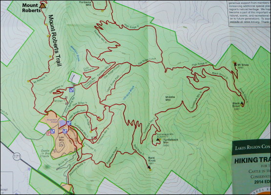
Click to see the Map of Mount Roberts larger and the entire Castle in the Clouds estate.
|
| |
|
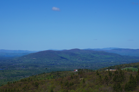
Looking at the Castle in the Clouds on 5-18-2014.
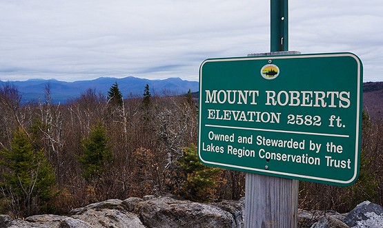
Photo taken from the summit of Mount Roberts on 5-18-2014.
|
| Mount Roberts Driving Directions |
Top |
These are driving directions to hike Mount Roberts:
From I-93, take exit 23 to Route 104 East (NH 132 North). Drive just over 8 miles and turn left onto US-3-North. Drive 0.9 miles and turn right onto Route 25 East / Winnipesaukee St. Drive for 10.2 miles and turn right onto Route 109 South. Drive 2.2 miles and continue straight on Route 171 East. Drive 0.5 miles and turn left onto Ossipee Park Road. Drive roughly 1.3 miles to the parking area.
|
|
On this page: Information | Trail maps | View Photos | Driving Directions | Top
|
|
|
|
|
|
|
|
|
|
| |
|
|
|
| |
| New Hampshire 4,000 Footers |
Vermont + Maine 4,000 Footers |
Other Hiking Lists / Patches |
New England Mountain Ranges |
Stay Involved in New England |
New Hampshire
Mount Adams
Mount Bond
Bondcliff
Mount Bond, West Peak
Mount Cabot
Cannon Mountain
Mount Carrigain
Carter Dome
Carter, Middle
Carter, South
Mount Eisenhower
Mount Field
Mount Flume
Mount Galehead
Mount Garfield
Mount Hale
Mount Hancock
Mount Hancock, South Peak
Mount Isolation
Mount Jackson
Mount Jefferson
Mount Kinsman, North Peak
Mount Kinsman, South Peak
Mount Lafayette
Mount Liberty
Mount Lincoln
Mount Madison
Mount Monroe
Mount Moosilauke
Mount Moriah
Mount Osceola
Mount Osceola, East Peak
Owl's Head
Mount Passaconway
Mount Pierce
Mount Tecumseh
Mount Tom
Mount Tripyramid, Middle Peak
Mount Tripyramid, North Peak
Mount Twin, North Peak
Mount Twin, South Peak
Mount Washington
Mount Waumbek
Mount Whiteface
Mount Wildcat, A Peak
Mount Wildcat, D Peak
Mount Willey
Zealand Mountain |
Vermont
Mount Abraham
Camel's Hump
Mount Ellen
Killington Peak
Mount Mansfield
Maine
Mount Abraham
Mount Bigelow, Avery Peak
Mount Bigelow, West Peak
Crocker Mountain
Crocker Mountain, South
Mount Katahdin, Baxter Peak
Mount Katahdin, Hamlin Peak
North Brother Mountain
Old Speck Mountain
Mount Redington
Saddleback Mountain
Saddleback Mountain, The Horn
Spaulding Mountain
Sugarloaf Mountain |
NH 4,000 footers
NH 4,000 footers in Winter
New England 4,000 footers
NE 4,000 footers in Winter
NH Hundred Highest
New England Fifty Finest
52 With a view
Trailwrights 72 summit club
New England Hundred highest
NE Hundred highest in Winter
Northeast 111
48x12 "The Grid"
Red Lining
Belknap Range
LRCT / Castle in the Clouds
NH Fire Tower Quest
Hike by - Alphabetically
Hike by - Elevation
Hike by - Prominence
Hike by - Mountain Range |
Ranges in New Hampshire
View all NH mountain ranges
Baldface-Royce Range
Carter-Moriah Range
Dartmouth Range
Franconia Range
Kinsman Range
Mahoosuc
Range
Ossipee Mountains
Northern Ranges
Pemigewasset Wilderness
Pilot Range
Pliny Range
Presidential Range
Sandwich Range
Twin Range
Wapack Range
Western White Mountains
Willey Range
Ranges in Maine
View all ME mountain ranges
Baxter State Park
High Peaks
Bigelow Range
Eastern White Mountains
Ranges in Vermont
Green Mountains
Other VT mountain ranges |
NH Waterfalls
NH AMC Huts
Hiker's store |
New England 4,000 Footers | NH 4,000 Footers | VT 4,000 Footers | ME 4,000 Footers | Hiking Lists & Patches | Hiker's Store | Contact by email
© www.4000footers.com 2015. All rights reserved. We are not affiliated with the AMC or the AMC Four Thousand Footer Club |
|
|