New England Hiking - www.4000footers.com

Hiking Mount Coe

 
On this page: Information | Trail maps | View Photos | Driving Directions
 
Mount Coe Mountain Information

Elevation: 3,795 feet (1,157 meters)
Prominence: What is Prominence? 315 feet (96 meters)
Location: Baxter State Park, Piscataquis County, Maine
Range: Baxter State Park
Coordinates: 45°56'01" North     69°00'32" West
Rating: How do the ratings work? Difficult / Very Difficult (if the Mount Coe Trail is wet, this can be very dangerous)
Features: Peak bag What is Peak Bagging?, New England Hundred highest
Distance of highlighted hike below: Roughly 13.2 miles with North Brother, South Brother and Fort Mountain. (Of course you can hike just Mount Coe at just about 6 miles round-trip)

Mount Coe is a 3,795 foot mountain in the Baxter State Park in Piscataquis County, Maine. It is just about 5.5 miles Northwest of the highest point in Maine, Mount Katahdin. Mount Coe is flanked to the Northeast by South Brother Mountain and to the Southwest by Mount OJI.

Mount Coe is on the New England Hundred highest list. The only way to access Mount Coe's summit is via the Marston Trail and the Mount Coe Trail.

Lists Mount Coe are on: = A patch is available for this list
New England Hundred highest
New England Hundred highest in Winter season


Mount Coe Trail Maps - Directions from the parking lot to the summit Top

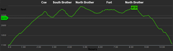
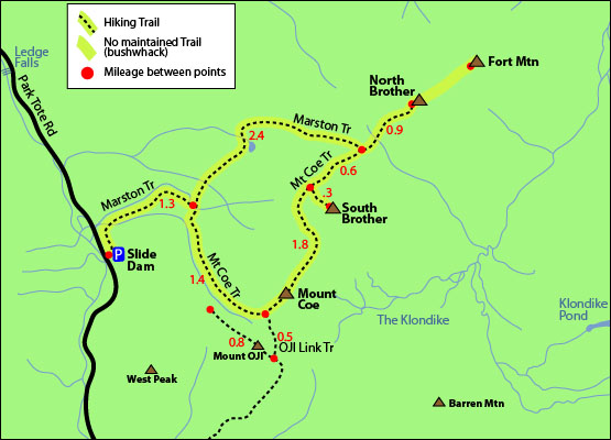
The map below shows how to get to the summit of Mount Coe as well as North Brother Mountain, South Brother and Fort Mountain, which are all on the New England Hundred Highest hiking list. Of course you can just hike just Mount Coe if you would like at just around 6 miles round-trip.

(NOTE: IF YOU INCLUDE FORT MOUNTAIN IN YOUR HIKE, LIKE THE MAP BELOW SHOWS, THIS IS A BUSHWHACK HIKE. THERE IS NO MAINTAINED TRAIL TO THE SUMMIT OF FORT MOUNTAIN, SO ONLY ATTEMPT THIS IF YOU ARE SMART WITH A NAVIGATION SYSTEM OR ARE ACCOMPANYING SOMEONE WHO IS.)

(NOTE: IT IS RECOMMENDED THAT IF YOU CHOOSE TO HIKE THIS LOOP, TO DO IT COUNTER CLOCKWISE BECAUSE THE MOUNT COE TRAIL IS ALL ROCK SLIDES AND IS VERY DIFFICULT TO HIKE DOWN. [ESPECIALLY WHEN WET] USE CAUTION.)

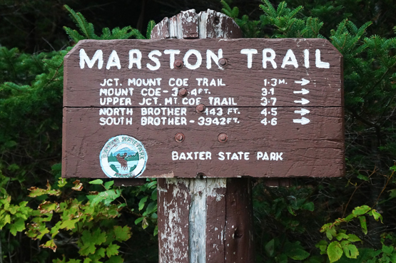
From the Marston Trailhead parking lot (near Slide Dam day use site parking area), head up the Marston Trail and hike for 1.3 miles until you come to a junction with the Mount Coe Trail (right) and the Marston Trail (left). You can go either way, depending on which mountains you want to hit first, but these directions will go right to hit Mount Coe first.

Go right on the Mount Coe Trail and hike roughly 1.7 miles until you reach the summit of Mount Coe. (At 1.4 miles you will have passed a junction with the OJI Link Trail.) After you summit Mount Coe, you can choose to hike back down to the parking lot, or continue on to peak bag the other mountains.

From the summit of Coe, continue on the Mount Coe Trail for roughly 1.5 miles until you reach a trail on your right to head up to the summit of South Brother Mountain. After your stay on South Brother, head back down the 0.3 mile trail to get back onto the Mount Coe Trail. Go right and hike for 1.5 miles until you reach the summit of North Brother. (At 0.6 miles you will have passed a junction with the Marston Trail, which you will take on the way down.)

If you wish to continue to bushwhack over to Fort Mountain, look for a few cairns (rock piles) indicating where the herd path is to your left. Follow for roughly 1 mile to the summit of Fort Mountain. You might come across a few junctions shortly after heading into treeline. The first one goes left and straight. The easier way (if there really is one) is to go left. At the second junction, which goes straight and right, you will want to go right. Again, do not attempt this bushwhack unless you are comfortable with hiking off trail.

To head back to the parking area, hike back over to North Brother via the same bushwhack you just took. From the summit of North Brother, hike down the Marston Trail for 0.9 miles until you come to the same junction you were at before with the Mount Coe Trail. Go right to stay on the Marston Trail and continue for 3.7 miles until you reach the parking area. (At 2.4 miles you will have passed a junction with the Mount Coe Trail again.)


hiking trail map north brother maine 4000 footers new england mount coe, south brother, fort mountain, martston trail, mount coe trail, park tote road, bushwhack
Click to download PDF Trail Map of Mount Coe


fort mountain elevation graph map profile north brother south brother mount coe gps map
 
 
Mount Coe View Photos Top


marston trail traillhead sign baxter state park maine
Trailhead sign at the beginning of the Marston Trail.


summit mount coe maine
Near the summit of Mount Coe on a cloudy/rainy day on August 31, 2014.


mount coe trail maine
Heading up the Mount Coe Trail on a cloudy/rainy day on August 31, 2014.


mount coe summit sign maine
Mount Coe summit sign on August 31, 2014.


views from mount coe summit maine
Views from the summit of Mount Coe on a cloudy/rainy day on August 31, 2014.


views from mount coe trail maine
Views from the Mount Coe Trail on a cloudy/rainy day on August 31, 2014.


Mount Coe Driving Directions Top

From I-95 North, take exit 144-244 for Maine 157 towards Medway / Millinocket. Go left off the off ramp to go West on Route 157 / West Medway Road. Drive 11.3 miles. Turn right onto Katahdin Road. Drive 0.2 miles. Take the 2nd left onto Bates Street. Drive 0.9 miles. Continue onto Millinocket Road. Drive 6.2 miles. Continue onto Millinocket Lake Road. Drive 1.1 miles. Continue onto Baxter Park Road. Drive 6.8 miles. Turn right to stay on Baxter Park Road. Drive 1.9 miles. Slight left onto Park Tote Road. Drive roughly 13.1 miles until you reach the Marston Trailhead parking area (near the Slide Dam Day Use Site parking area.)

NOTE: The trailhead is 13.1 miles from the gate at the Baxter State Park South entrance.


On this page: Information | Trail maps | View Photos | Driving Directions | Top


Sign up for our Newsletter!
https://www.facebook.com/groups/4000footers/ fb facebook 4000 footers page hiking


New Hampshire 4,000 Footers Vermont + Maine 4,000 Footers Other Hiking Lists / Patches New England Mountain Ranges Stay Involved in New England

New Hampshire
Mount Adams
Mount Bond
Bondcliff
Mount Bond, West Peak
Mount Cabot
Cannon Mountain
Mount Carrigain
Carter Dome
Carter, Middle
Carter, South
Mount Eisenhower
Mount Field
Mount Flume
Mount Galehead
Mount Garfield
Mount Hale
Mount Hancock
Mount Hancock, South Peak
Mount Isolation
Mount Jackson
Mount Jefferson
Mount Kinsman, North Peak
Mount Kinsman, South Peak
Mount Lafayette
Mount Liberty
Mount Lincoln
Mount Madison
Mount Monroe
Mount Moosilauke
Mount Moriah
Mount Osceola
Mount Osceola, East Peak
Owl's Head
Mount Passaconway
Mount Pierce
Mount Tecumseh
Mount Tom
Mount Tripyramid, Middle Peak
Mount Tripyramid, North Peak
Mount Twin, North Peak
Mount Twin, South Peak
Mount Washington
Mount Waumbek
Mount Whiteface
Mount Wildcat, A Peak
Mount Wildcat, D Peak
Mount Willey
Zealand Mountain

Vermont
Mount Abraham

Camel's Hump
Mount Ellen
Killington Peak
Mount Mansfield

Maine
Mount Abraham
Mount Bigelow, Avery Peak
Mount Bigelow, West Peak
Crocker Mountain
Crocker Mountain, South
Mount Katahdin, Baxter Peak
Mount Katahdin, Hamlin Peak
North Brother Mountain
Old Speck Mountain
Mount Redington
Saddleback Mountain
Saddleback Mountain, The Horn
Spaulding Mountain
Sugarloaf Mountain

NH 4,000 footers
NH 4,000 footers in Winter
New England 4,000 footers
NE 4,000 footers in Winter
NH Hundred Highest
New England Fifty Finest
52 With a view
Trailwrights 72 summit club
New England Hundred highest
NE Hundred highest in Winter
Northeast 111
48x12 "The Grid"
Red Lining
Belknap Range
LRCT / Castle in the Clouds
NH Fire Tower Quest

Hike by - Alphabetically
Hike by - Elevation
Hike by - Prominence
Hike by - Mountain Range

Ranges in New Hampshire
View all NH mountain ranges
Baldface-Royce Range
Carter-Moriah Range
Dartmouth Range
Franconia Range
Kinsman Range
Mahoosuc Range
Ossipee Mountains
Northern Ranges
Pemigewasset Wilderness
Pilot Range
Pliny Range
Presidential Range
Sandwich Range
Twin Range
Wapack Range
Western White Mountains
Willey Range

Ranges in Maine
View all ME mountain ranges

Baxter State Park
High Peaks
Bigelow Range
Eastern White Mountains

Ranges in Vermont
Green Mountains
Other VT mountain ranges

NH Waterfalls

NH AMC Huts

Hiker's store

New England 4,000 Footers | NH 4,000 Footers | VT 4,000 Footers | ME 4,000 Footers | Hiking Lists & Patches | Hiker's Store | Contact by email

© www.4000footers.com 2015. All rights reserved.  We are not affiliated with the AMC or the AMC Four Thousand Footer Club