New England Hiking - www.4000footers.com

Hike / Bushwhack to Scar Ridge

 
On this page: Information | Trail maps | View Photos | Driving Directions
 
Scar Ridge Information

Elevation: 3,774 feet (1,150 meters)
Prominence: What is Prominence? 654 feet (199 meters)
Location: Lincoln, (Grafton County) New Hampshire
Range: Sandwich Range
Coordinates: 44°01'43" North     71°35'34" West
Rating: How do the ratings work? Difficult (You first hike up the steep ski trails of Loon Mountain, followed by an easy herd path, then a difficult bushwhack.)
Features: Bushwhack, no views on the summit, Loon Mountain Ski Resort (excellent views most of the way up and on the summit.)
Distance of highlighted hike below: Roughly 8-10 miles (depends on the herd path and bushwhack distance)

Scar Ridge, also known as Scar Ridge West Peak, is a 3,774 foot mountain in the Sandwich Range of the White Mountains of New Hampshire. There is no trail leading up to the summit of the mountain so the only way to summit this peak is by bushwhacking. This mountain is on the New England Hundred Highest hiking list as well as the New Hampshire Hundred highest.

The mountain is flanked to the West by Loon Mountain, to the Northwest by Black Mountain and to the East by Mount Osceola.


Lists Scar Ridge are on: = A patch is available for this list
New England Hundred highest
New England Hundred highest in Winter season
     New Hampshire Hundred highest


Scar Ridge Trail Maps - Directions from the parking lot to the summit Top

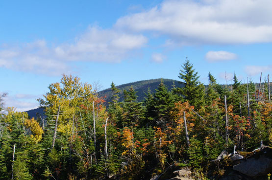
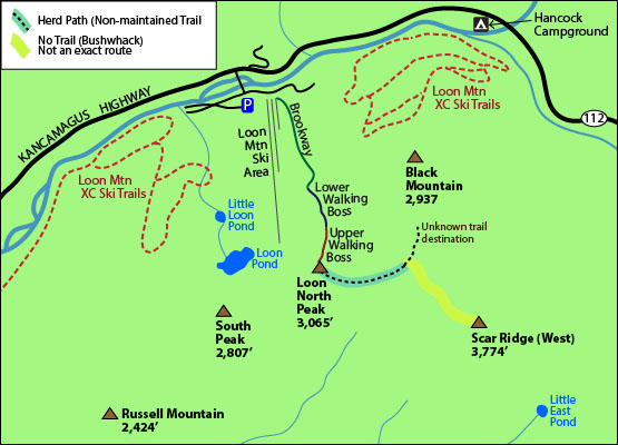
The map below shows how to get to the summit of Scar Ridge. (Note: The highlighted map below shows an approximate location of where you can begin the bushwhack in an area that is not so dense. It is not an exact location.)

(NOTE THIS IS A BUSHWHACK HIKE. THERE IS NO MAINTAINED TRAIL TO THE SUMMIT OF SCAR RIDGE, SO ONLY ATTEMPT THIS IF YOU ARE SMART WITH A NAVIGATION SYSTEM AND/OR KNOW WHAT YOU ARE DOING.)

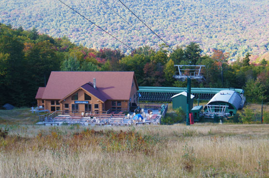
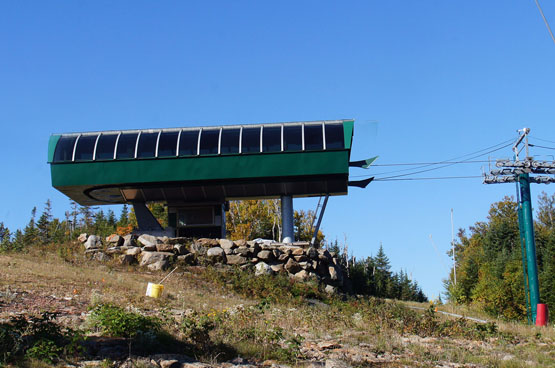
From the back of the Loon Mountain Ski Resort lodge, take the furthest trail to the left called the Brookway. Hike all the way up until you see the orange colored lodge (Camp III Lodge). From there hike up the Lower Walking Boss Woods ski trail (which is a black diamond trail). Then continue up the Upper Walking Boss trail (also a black diamond trail). At the top of this trail is the summit of (North) Loon Mountain, and the ski quad.

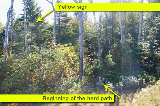
The herd path that begins your journey up to Scar Ridge, begins about a hundred or so feet lower than the quad on the Upper Walking Boos trail. (If you are hiking up that trail you will see a yellow sign really high up in the trees on the left side that says you are entering an unmaintained trail. That is the start of the herd path.) If you don't see any yellow sign, just look for a path in that area. It is an old ski trail, so it is easy to navigate.

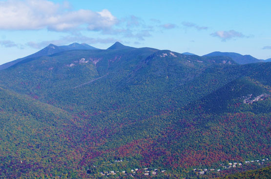
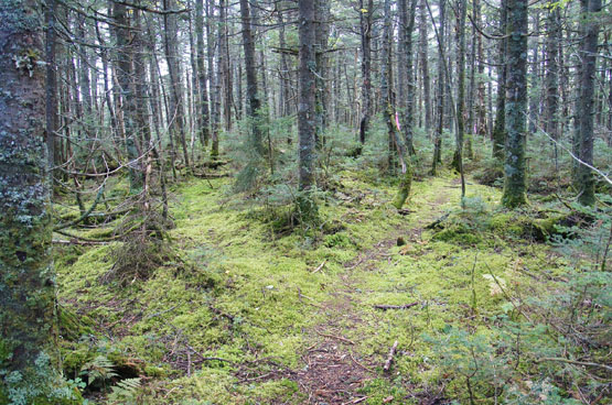
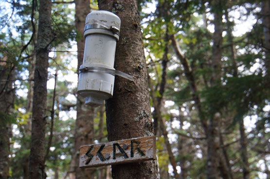
Hike on that herd path for roughly 0.6 miles. At that point, you can start the bushwhack really anywhere in that area on the right side. That area is not too dense, so it is a great starting point. This begins your bushwhack up to Scar Ridge! There is not really any herd path in the woods, except maybe a few areas close to the summit, so a good GPS comes in handy to locate the actual summit. There is a canister and a summit sign.

This hike can be as little as 8.5 miles, depending on your bushwhack route, but can also be closer to 10 if you aren't going directly towards the summit during your whack.

trail map scar ridge west hiking map bushwhack loon mountain ski area loon mountain scar ridge west peak brookway, lower walking boss, upper walking boss ski trail kancamagus 112 new england hundred highest maps
Click to download PDF Trail Map of Scar Ridge


Scar Ridge View Photos Top


loon mountain camp III lodge nh
Camp III Lodge at the top of the Brookway ski trail and the bottom of the Lower Walking Boss Woods ski trail. Taken on 9/24/14.


loon mounatin summit views fall foliage
Views heading up the Loon ski trails. Taken on 9/24/14.


quad ski lift loon mountain summit
The quad on the summit of Loon Mountain. Taken on 9/24/14.


scar ridge mountain mount nh
View of Scar Ridge from the summit of Loon Mountain. Taken on 9/24/14.


yellow sign herd path scar ridge loon mountain
The yellow sign indicating where the herd path begins (can be easily missed!). Taken on 9/24/14.


herd path on scar ridge mountain nh
Some stretch of herd path near the summit of Scar Ridge. Taken on 9/24/14.


summit scar ridge hiking caniter sign photo summit nh
Summit sign and canister on Scar Ridge. Taken on 9/24/14.


Scar Ridge Driving Directions Top

The parking lot for the highlighted hike is at the Loon Mountain Ski Resort. If you have a GPS, just enter 60 Loon Mountain Road in Lincoln, New Hampshire. (This road is right off Route 112, the Kancamagus Highway.)


On this page: Information | Trail maps | View Photos | Driving Directions | Top

Sign up for our Newsletter!
https://www.facebook.com/groups/4000footers/ fb facebook 4000 footers page hiking


New Hampshire 4,000 Footers Vermont + Maine 4,000 Footers Other Hiking Lists / Patches New England Mountain Ranges Stay Involved in New England

New Hampshire
Mount Adams
Mount Bond
Bondcliff
Mount Bond, West Peak
Mount Cabot
Cannon Mountain
Mount Carrigain
Carter Dome
Carter, Middle
Carter, South
Mount Eisenhower
Mount Field
Mount Flume
Mount Galehead
Mount Garfield
Mount Hale
Mount Hancock
Mount Hancock, South Peak
Mount Isolation
Mount Jackson
Mount Jefferson
Mount Kinsman, North Peak
Mount Kinsman, South Peak
Mount Lafayette
Mount Liberty
Mount Lincoln
Mount Madison
Mount Monroe
Mount Moosilauke
Mount Moriah
Mount Osceola
Mount Osceola, East Peak
Owl's Head
Mount Passaconway
Mount Pierce
Mount Tecumseh
Mount Tom
Mount Tripyramid, Middle Peak
Mount Tripyramid, North Peak
Mount Twin, North Peak
Mount Twin, South Peak
Mount Washington
Mount Waumbek
Mount Whiteface
Mount Wildcat, A Peak
Mount Wildcat, D Peak
Mount Willey
Zealand Mountain

Vermont
Mount Abraham

Camel's Hump
Mount Ellen
Killington Peak
Mount Mansfield

Maine
Mount Abraham
Mount Bigelow, Avery Peak
Mount Bigelow, West Peak
Crocker Mountain
Crocker Mountain, South
Mount Katahdin, Baxter Peak
Mount Katahdin, Hamlin Peak
North Brother Mountain
Old Speck Mountain
Mount Redington
Saddleback Mountain
Saddleback Mountain, The Horn
Spaulding Mountain
Sugarloaf Mountain

NH 4,000 footers
NH 4,000 footers in Winter
New England 4,000 footers
NE 4,000 footers in Winter
NH Hundred Highest
New England Fifty Finest
52 With a view
Trailwrights 72 summit club
New England Hundred highest
NE Hundred highest in Winter
Northeast 111
48x12 "The Grid"
Red Lining
Belknap Range
LRCT / Castle in the Clouds
NH Fire Tower Quest

Hike by - Alphabetically
Hike by - Elevation
Hike by - Prominence
Hike by - Mountain Range

Ranges in New Hampshire
View all NH mountain ranges
Baldface-Royce Range
Carter-Moriah Range
Dartmouth Range
Franconia Range
Kinsman Range
Mahoosuc Range
Ossipee Mountains
Northern Ranges
Pemigewasset Wilderness
Pilot Range
Pliny Range
Presidential Range
Sandwich Range
Twin Range
Wapack Range
Western White Mountains
Willey Range

Ranges in Maine
View all ME mountain ranges

Baxter State Park
High Peaks
Bigelow Range
Eastern White Mountains

Ranges in Vermont
Green Mountains
Other VT mountain ranges

NH Waterfalls

NH AMC Huts

Hiker's store

New England 4,000 Footers | NH 4,000 Footers | VT 4,000 Footers | ME 4,000 Footers | Hiking Lists & Patches | Hiker's Store | Contact by email

© www.4000footers.com 2015. All rights reserved.  We are not affiliated with the AMC or the AMC Four Thousand Footer Club