| New England 100 Highest List ↓ |
| Mount Abraham - Maine |
| Mount Abraham - Vermont |
| Mount Adams |
| Baldpate Mountain |
| Mount Bigelow, Avery Peak |
| Mount Bigelow, West Peak |
| Mount Bigelow, South Horn |
| Big Jay |
| Mount Bond |
| Bondcliff |
| Mount Bond, West Peak |
| Boundary Peak |
| Bread Loaf Mountain |
| Mount Cabot |
| Camel's Hump |
| Cannon Mountain |
| Cannon Ball, Northeast Peak |
| Mount Carrigain |
| Carter Dome |
| Carter, Middle |
| Carter, South |
| Mount Coe |
| Crocker Mountain |
| Crocker Mountain, South |
| Dorset Mountain |
| Mount Eisenhower |
| Elephant Mountain |
| Mount Ellen |
| Equinox Mountain |
| Mount Field |
| Mount Flume |
| Fort Mountain |
| Mount Galehead |
| Mount Garfield |
| Goose Eye Mountain |
| Mount Hale |
| Mount Hancock |
| Mount Hancock, South Peak |
| Mount Isolation |
| Mount Jackson |
| Jay Peak |
| Mount Jefferson |
| Mount Katahdin, Baxter Peak |
| Mount Katahdin, Hamlin Peak |
| Kennebago Divide |
| East Kennebago Mountain |
| Killington Peak |
| Mount Kinsman, North Peak |
| Mount Kinsman, South Peak |
| Mount Lafayette |
| Mount Liberty |
| Mount Lincoln |
| Mount Madison |
| Mount Mansfield |
| Mendon Peak |
| Mount Monroe |
| Mount Moosilauke |
| Mount Moriah |
| Mount Nancy |
| North Brother Mountain |
| Old Speck Mountain |
| Mount Osceola |
| Mount Osceola, East Peak |
| Owl's Head |
| Mount Passaconway |
| Peak Above the Nubble (PATN) |
| Pico Peak |
| Mount Pierce |
| Mount Redington |
| Saddleback Mountain |
| Saddleback Mountain, The Horn |
| Sandwich Mountain |
| Scar Ridge |
| Sleeper, East Peak |
| Snow Mountain - Franklin County |
| Snow Mountain - Oxford County |
| South Brother |
| Spauling Mountain |
| Stratton Mountain |
| Sugarloaf Mountain |
| Mount Tecumseh |
| The Bulge |
| The Horn |
| Mount Tom |
| Mount Tripyramid, Middle Peak |
| Mount Tripyramid, North Peak |
| Mount Twin, North Peak |
| Mount Twin, South Peak |
| Vose Spur |
| Mount Washington |
| Mount Waumbek |
| Mount Weeks |
| Mount Weeks, South |
| White Cap Mountain |
| Mount Whiteface |
| Mount Wildcat, A Peak |
| Mount Wildcat, D Peak |
| Mount Willey |
| Mount Wilson |
Zealand Mountain |
|
|
Hike / Bushwhack to Vose Spur |
| |
| On this page: Information | Trail maps | View Photos | Driving Directions |
| |
Elevation: 3,862 feet (1,177 meters)
Prominence:  222 feet (68 meters) 222 feet (68 meters)
Location: Livermore, New Hampshire (Grafton County)
Range: Pemigewasset Wilderness
Coordinates: 44°06'11" North 71°26'05" West
Rating: Very Difficult - The miles on the Signal Ridge Trail & the Carrigain Notch Trail are easy, but the bushwhack to the summit is very difficult, steep and strenuous. It does not always have a herd path.
Features: Bushwhack, no views on the summit, but great views on the rock field during the bushwhack.
Distance of highlighted hike below: Roughly 10 miles (depends on the bushwhack distance)
|
 |
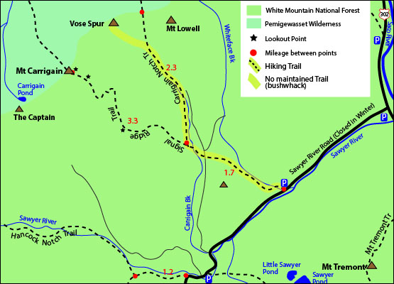
Vose Spur is a sub peak of Mount Carrigain and has an elevation of 3,862 feet. It is in the Pemigewasset Wilderness of the White Mountains in New Hampshire. There is no trail to the summit of the mountain, so the only way to reach the top is by bushwhacking. The best route to bushwhack is to hike on the Signal Ridge Trail from Sawyer River Road in Livermore, NH then bear right to hike on the Carrigain Notch Trail. (The bushwhack begins off this trail, see directions below.)
The mountain was named after George L. Vose. The summit is densely wooded with no views, though you can catch great views on the way up on the rock field during the bushwhack looking at Carrigain notch and Mount Lowell.
|
| Vose Spur Trail Maps - Directions from the parking lot to the summit |
Top |
The map below shows how to get to the summit of Vose Spur. (Note: The highlighted map below shows an approximate location of where the bushwhack begins. It is not an exact.)
(NOTE THIS IS A BUSHWHACK HIKE. THERE IS NO MAINTAINED TRAIL TO THE SUMMIT OF VOSE SPUR, SO ONLY ATTEMPT THIS IF YOU ARE SMART WITH A NAVIGATION SYSTEM AND/OR KNOW WHAT YOU ARE DOING.)
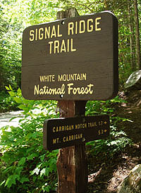
From the Signal Ridge Traillhead on Sawyer River Road in Livermore, NH, hike along the Signal Ridge Trail for 1.7 miles until you come to a junction with the Carrigian Notch Trail. Take the Carrigian Notch Trail on the right and hike for roughly the same distance. You are looking for a huge rock (pictured below). When you reach this huge rock continue hiking for about a minute or less until you see some birch logs on the ground on the left (see photo below). This log indicates the start of the bushwhack. Hop over the log and start whackin' your way up to the summit of Vose Spur! There are no further directions to the summit, as this is a very difficult and strenuous bushwhack and should only be attempted if you have a navigation system and/or know what you are doing. There is some herd path along the way, but chances are you won't be on it the entire way because this is a dense wilderness area with many blown-down trees.
To get back to the parking area, go back the same way you came up.
Click to download PDF Trail Map of Vose Spur
|
| |
|
| |
| Vose Spur View Photos |
Top |
|
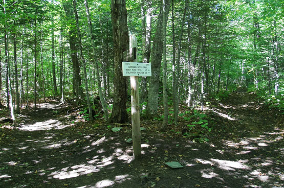
Junction of the Signal Ridge Trail and the Carrigain Notch Trail on the right. Taken on 9/14/14.
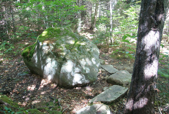
The big rock to look for right before the bushwhack begins. Taken on 9/14/14.
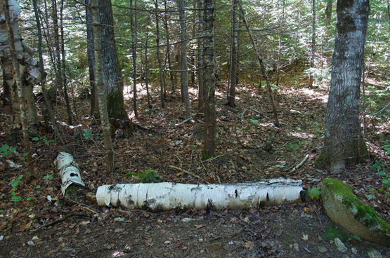
The birch logs that mark the beginning of the bushwhack up to Vose Spur. Taken on 9/14/14.
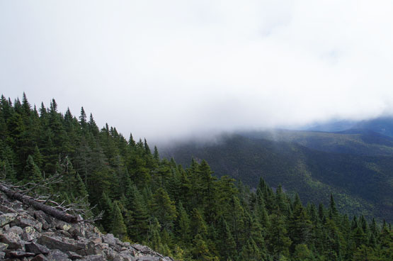
Views along the rock field during the bushwhack up to Vose Spur. Taken on 9/14/14.
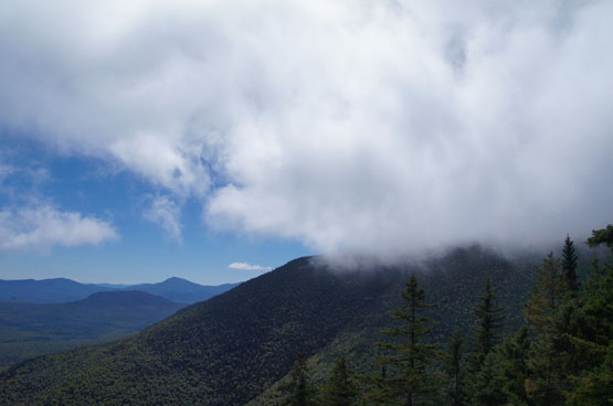
Views along the rock field during the bushwhack up to Vose Spur. Taken on 9/14/14.
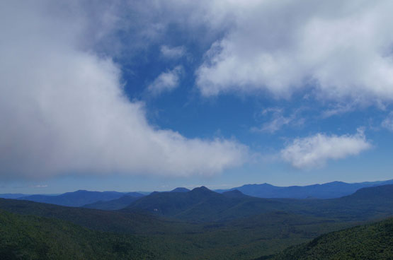
Views along the rock field during the bushwhack up to Vose Spur. Taken on 9/14/14.
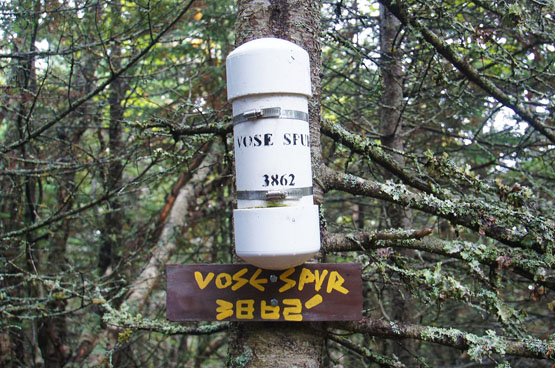
Summit sign and canister on Vose Spur! Taken on 9/14/14.
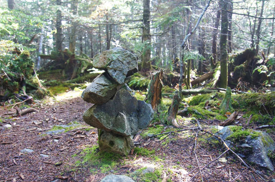
Summit cairn on Vose Spur. Taken on 9/14/14.
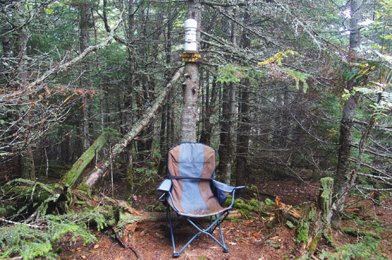
Summit sign, canister and summit chair on Vose Spur! Taken on 9/14/14.
|
| Vose Spur Driving Directions |
Top |
The parking lot for the highlighted hike above is located on Sawyer River Road in Livermore, NH. (Some GPSs won't have Livermore, New Hampshire programmed in.)
Take exit 35 off I-93 South. Head North on Route 3 towards Twin Mountain / Lancaster. Drive 10.3 miles and turn right onto Route 302 East. Drive 19 miles on Route 302 until you reach Sawyer River Road. Drive roughly 2 miles until you reach a parking lot on the left side for the Signal Ridge Trail. It is a dirt road that is closed in the Winter.
The Signal Ridge Trail begins across the street from the parking lot. |
|
 |
|
|
On this page: Information | Trail maps | View Photos | Driving Directions | Top
|
|
|
|
|
|
|
|
|
|
|
|
|
| |
| |
|
| New Hampshire 4,000 Footers |
Vermont + Maine 4,000 Footers |
Other Hiking Lists / Patches |
New England Mountain Ranges |
Stay Involved in New England |
New Hampshire
Mount Adams
Mount Bond
Bondcliff
Mount Bond, West Peak
Mount Cabot
Cannon Mountain
Mount Carrigain
Carter Dome
Carter, Middle
Carter, South
Mount Eisenhower
Mount Field
Mount Flume
Mount Galehead
Mount Garfield
Mount Hale
Mount Hancock
Mount Hancock, South Peak
Mount Isolation
Mount Jackson
Mount Jefferson
Mount Kinsman, North Peak
Mount Kinsman, South Peak
Mount Lafayette
Mount Liberty
Mount Lincoln
Mount Madison
Mount Monroe
Mount Moosilauke
Mount Moriah
Mount Osceola
Mount Osceola, East Peak
Owl's Head
Mount Passaconway
Mount Pierce
Mount Tecumseh
Mount Tom
Mount Tripyramid, Middle Peak
Mount Tripyramid, North Peak
Mount Twin, North Peak
Mount Twin, South Peak
Mount Washington
Mount Waumbek
Mount Whiteface
Mount Wildcat, A Peak
Mount Wildcat, D Peak
Mount Willey
Zealand Mountain |
Vermont
Mount Abraham
Camel's Hump
Mount Ellen
Killington Peak
Mount Mansfield
Maine
Mount Abraham
Mount Bigelow, Avery Peak
Mount Bigelow, West Peak
Crocker Mountain
Crocker Mountain, South
Mount Katahdin, Baxter Peak
Mount Katahdin, Hamlin Peak
North Brother Mountain
Old Speck Mountain
Mount Redington
Saddleback Mountain
Saddleback Mountain, The Horn
Spaulding Mountain
Sugarloaf Mountain |
NH 4,000 footers
NH 4,000 footers in Winter
New England 4,000 footers
NE 4,000 footers in Winter
NH Hundred Highest
New England Fifty Finest
52 With a view
Trailwrights 72 summit club
New England Hundred highest
NE Hundred highest in Winter
Northeast 111
48x12 "The Grid"
Red Lining
Belknap Range
LRCT / Castle in the Clouds
NH Fire Tower Quest
Hike by - Alphabetically
Hike by - Elevation
Hike by - Prominence
Hike by - Mountain Range |
Ranges in New Hampshire
View all NH mountain ranges
Baldface-Royce Range
Carter-Moriah Range
Dartmouth Range
Franconia Range
Kinsman Range
Mahoosuc
Range
Ossipee Mountains
Northern Ranges
Pemigewasset Wilderness
Pilot Range
Pliny Range
Presidential Range
Sandwich Range
Twin Range
Wapack Range
Western White Mountains
Willey Range
Ranges in Maine
View all ME mountain ranges
Baxter State Park
High Peaks
Bigelow Range
Eastern White Mountains
Ranges in Vermont
Green Mountains
Other VT mountain ranges |
NH Waterfalls
NH AMC Huts
Hiker's store |
New England 4,000 Footers | NH 4,000 Footers | VT 4,000 Footers | ME 4,000 Footers | Hiking Lists & Patches | Hiker's Store | Contact by email
© www.4000footers.com 2015. All rights reserved. We are not affiliated with the AMC or the AMC Four Thousand Footer Club |
|
|