| New England 100 Highest List ↓ |
| Mount Abraham - Maine |
| Mount Abraham - Vermont |
| Mount Adams |
| Baldpate Mountain |
| Mount Bigelow, Avery Peak |
| Mount Bigelow, West Peak |
| Mount Bigelow, South Horn |
| Big Jay |
| Mount Bond |
| Bondcliff |
| Mount Bond, West Peak |
| Boundary Peak |
| Bread Loaf Mountain |
| Mount Cabot |
| Camel's Hump |
| Cannon Mountain |
| Cannon Ball, Northeast Peak |
| Mount Carrigain |
| Carter Dome |
| Carter, Middle |
| Carter, South |
| Mount Coe |
| Crocker Mountain |
| Crocker Mountain, South |
| Dorset Mountain |
| Mount Eisenhower |
| Elephant Mountain |
| Mount Ellen |
| Equinox Mountain |
| Mount Field |
| Mount Flume |
| Fort Mountain |
| Mount Galehead |
| Mount Garfield |
| Goose Eye Mountain |
| Mount Hale |
| Mount Hancock |
| Mount Hancock, South Peak |
| Mount Isolation |
| Mount Jackson |
| Jay Peak |
| Mount Jefferson |
| Mount Katahdin, Baxter Peak |
| Mount Katahdin, Hamlin Peak |
| Kennebago Divide |
| East Kennebago Mountain |
| Killington Peak |
| Mount Kinsman, North Peak |
| Mount Kinsman, South Peak |
| Mount Lafayette |
| Mount Liberty |
| Mount Lincoln |
| Mount Madison |
| Mount Mansfield |
| Mendon Peak |
| Mount Monroe |
| Mount Moosilauke |
| Mount Moriah |
| Mount Nancy |
| North Brother Mountain |
| Old Speck Mountain |
| Mount Osceola |
| Mount Osceola, East Peak |
| Owl's Head |
| Mount Passaconway |
| Peak Above the Nubble (PATN) |
| Pico Peak |
| Mount Pierce |
| Mount Redington |
| Saddleback Mountain |
| Saddleback Mountain, The Horn |
| Sandwich Mountain |
| Scar Ridge |
| Sleeper, East Peak |
| Snow Mountain - Franklin County |
| Snow Mountain - Oxford County |
| South Brother |
| Spauling Mountain |
| Stratton Mountain |
| Sugarloaf Mountain |
| Mount Tecumseh |
| The Bulge |
| The Horn |
| Mount Tom |
| Mount Tripyramid, Middle Peak |
| Mount Tripyramid, North Peak |
| Mount Twin, North Peak |
| Mount Twin, South Peak |
| Vose Spur |
| Mount Washington |
| Mount Waumbek |
| Mount Weeks |
| Mount Weeks, South |
| White Cap Mountain |
| Mount Whiteface |
| Mount Wildcat, A Peak |
| Mount Wildcat, D Peak |
| Mount Willey |
| Mount Wilson |
Zealand Mountain |
|
|
Hike Pico Peak |
| |
| On this page: Information | Trail maps | View Photos | Driving Directions |
| |
Elevation: 3,957 feet (1,206 meters)
Prominence:  590 feet (180 meters) 590 feet (180 meters)
Location: Killington, Vermont (Rutland County)
Range: Green Mountains
Coordinates: 43°38.36' North 72°50.18' West
Rating: Easy - For an almost 4,000 foot mountain, Pico Peak is relatively easy and straightforward via the Sherburne Pass Trail.
Features: Pico Camp, Pico Peak Ski Area, New England Hundred highest
Distance of highlighted hike below: 6.2 miles
|
 |
Pico Peak (pronounced pike-o) is a 3,957 foot mountain located in Killington, Vermont in Rutland County in the famous Green Mountains. There are 2 main hiking trails to reach the summit; Sherburne Pass Trail and the Long Trail, both off Route 4.
Pico Camp is just 0.4 miles East below the summit and offers bunk beds to overnight hikers.
Pico Peak is on the New England Hundred highest hiking list.
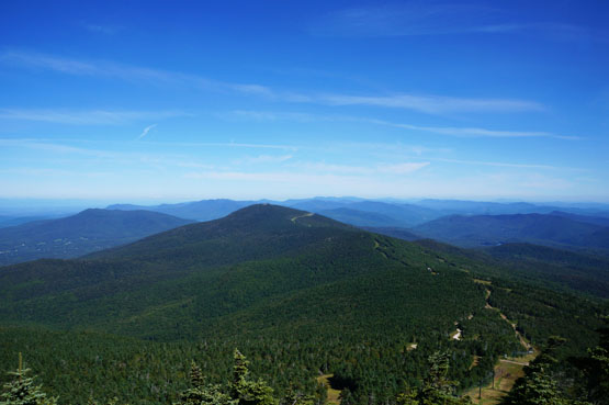
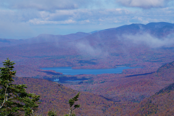
Pico Peak from Killington Peak on August 24, 2013.
|
| Pico Peak Trail Maps - Directions from the parking lot to the summit |
Top |
The map below shows how to get to the summit of Pico Peak.
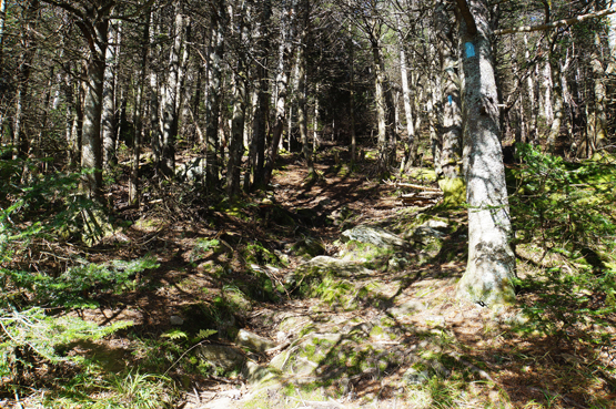
From the Sherburne Pass Traillhead parking area, hike on the Sherburne Pass Trail for 2.7 miles until you reach Pico Camp. (While on the trail, it will bring you to a ski trail. Hike up the ski trail for a very short distance and the Sherburne Pass Trail continues into the woods on the left side, though you can choose to hike up the ski trail instead if you want.)
Take the spur trail behind Pico Camp up for the last 0.4 miles until you reach the summit of Pico Peak! (More towards the top of Pico Peak you will cross directly across ski trails 2 more times before reaching the summit.)
To get back to the parking area, retrace your steps back down the spur trail for 0.4 miles, then down the Sherburne Pass Trail for 2.7 miles.
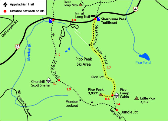
Click to download PDF Trail Map of Pico Peak
|
| |
|
| |
| Pico Peak View Photos |
Top |
|
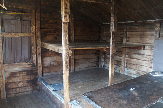
Inside of Pico Camp. Taken on 10/12/14.
The spur path up to Pico Peak, just past Pico Camp off the Sherburne Pass Trail. Taken on 10/12/14.
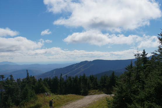
Looking at Killington Peak from the summit of Pico Peak. Taken on 10/12/14.
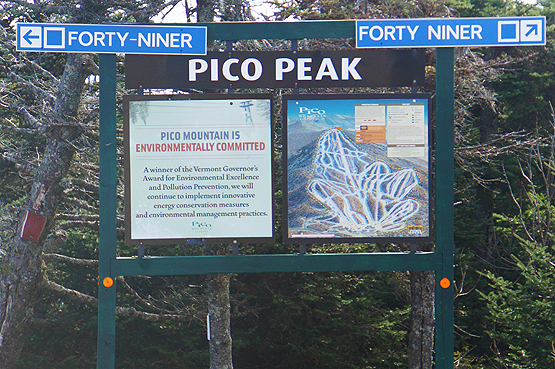
Ski trails sign near the top of Pico Peak. Taken on 10/12/14.
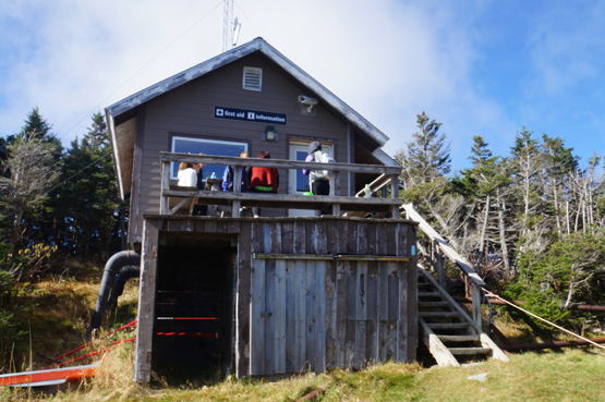
First Aid / Information building at the top of Pico Peak. Taken on 10/12/14.
Summit views from the top of Pico Peak. Taken on 10/12/14.
|
| Pico Peak Driving Directions |
Top |
If you have a GPS, you can enter the Inn at Long Trail, 709 U.S. 4, Killington, VT 05751. The parking lot is directly across the street from this inn.
From I-93 North and merge onto I-89 North towards Lebanon / White River Jct VT.
Take exit 1 off I-89 North. Turn left onto US Route 4 South. (Route 4 is also Part of Route100).
Drive (roughly 30 miles) on Route 4 until you reach the parking lot on the left side of the road for the Sherburne Pass Trail up to Pico Peak. (If you reach the Long Trail parking area or the entrance to Pico Peak Ski Area, you have driven a bit too far.)
|
|
On this page: Information | Trail maps | View Photos | Driving Directions | Top
|
|
|
|
|
|
|
|
|
|
|
|
|
| |
| |
|
| New Hampshire 4,000 Footers |
Vermont + Maine 4,000 Footers |
Other Hiking Lists / Patches |
New England Mountain Ranges |
Stay Involved in New England |
New Hampshire
Mount Adams
Mount Bond
Bondcliff
Mount Bond, West Peak
Mount Cabot
Cannon Mountain
Mount Carrigain
Carter Dome
Carter, Middle
Carter, South
Mount Eisenhower
Mount Field
Mount Flume
Mount Galehead
Mount Garfield
Mount Hale
Mount Hancock
Mount Hancock, South Peak
Mount Isolation
Mount Jackson
Mount Jefferson
Mount Kinsman, North Peak
Mount Kinsman, South Peak
Mount Lafayette
Mount Liberty
Mount Lincoln
Mount Madison
Mount Monroe
Mount Moosilauke
Mount Moriah
Mount Osceola
Mount Osceola, East Peak
Owl's Head
Mount Passaconway
Mount Pierce
Mount Tecumseh
Mount Tom
Mount Tripyramid, Middle Peak
Mount Tripyramid, North Peak
Mount Twin, North Peak
Mount Twin, South Peak
Mount Washington
Mount Waumbek
Mount Whiteface
Mount Wildcat, A Peak
Mount Wildcat, D Peak
Mount Willey
Zealand Mountain |
Vermont
Mount Abraham
Camel's Hump
Mount Ellen
Killington Peak
Mount Mansfield
Maine
Mount Abraham
Mount Bigelow, Avery Peak
Mount Bigelow, West Peak
Crocker Mountain
Crocker Mountain, South
Mount Katahdin, Baxter Peak
Mount Katahdin, Hamlin Peak
North Brother Mountain
Old Speck Mountain
Mount Redington
Saddleback Mountain
Saddleback Mountain, The Horn
Spaulding Mountain
Sugarloaf Mountain |
NH 4,000 footers
NH 4,000 footers in Winter
New England 4,000 footers
NE 4,000 footers in Winter
NH Hundred Highest
New England Fifty Finest
52 With a view
Trailwrights 72 summit club
New England Hundred highest
NE Hundred highest in Winter
Northeast 111
48x12 "The Grid"
Red Lining
Belknap Range
LRCT / Castle in the Clouds
NH Fire Tower Quest
Hike by - Alphabetically
Hike by - Elevation
Hike by - Prominence
Hike by - Mountain Range |
Ranges in New Hampshire
View all NH mountain ranges
Baldface-Royce Range
Carter-Moriah Range
Dartmouth Range
Franconia Range
Kinsman Range
Mahoosuc
Range
Ossipee Mountains
Northern Ranges
Pemigewasset Wilderness
Pilot Range
Pliny Range
Presidential Range
Sandwich Range
Twin Range
Wapack Range
Western White Mountains
Willey Range
Ranges in Maine
View all ME mountain ranges
Baxter State Park
High Peaks
Bigelow Range
Eastern White Mountains
Ranges in Vermont
Green Mountains
Other VT mountain ranges |
NH Waterfalls
NH AMC Huts
Hiker's store |
New England 4,000 Footers | NH 4,000 Footers | VT 4,000 Footers | ME 4,000 Footers | Hiking Lists & Patches | Hiker's Store | Contact by email
© www.4000footers.com 2015. All rights reserved. We are not affiliated with the AMC or the AMC Four Thousand Footer Club |
|
|