| New England 100 Highest List ↓ |
| Mount Abraham - Maine |
| Mount Abraham - Vermont |
| Mount Adams |
| Baldpate Mountain |
| Mount Bigelow, Avery Peak |
| Mount Bigelow, West Peak |
| Mount Bigelow, South Horn |
| Big Jay |
| Mount Bond |
| Bondcliff |
| Mount Bond, West Peak |
| Boundary Peak |
| Bread Loaf Mountain |
| Mount Cabot |
| Camel's Hump |
| Cannon Mountain |
| Cannon Ball, Northeast Peak |
| Mount Carrigain |
| Carter Dome |
| Carter, Middle |
| Carter, South |
| Mount Coe |
| Crocker Mountain |
| Crocker Mountain, South |
| Dorset Mountain |
| Mount Eisenhower |
| Elephant Mountain |
| Mount Ellen |
| Equinox Mountain |
| Mount Field |
| Mount Flume |
| Fort Mountain |
| Mount Galehead |
| Mount Garfield |
| Goose Eye Mountain |
| Mount Hale |
| Mount Hancock |
| Mount Hancock, South Peak |
| Mount Isolation |
| Mount Jackson |
| Jay Peak |
| Mount Jefferson |
| Mount Katahdin, Baxter Peak |
| Mount Katahdin, Hamlin Peak |
| Kennebago Divide |
| East Kennebago Mountain |
| Killington Peak |
| Mount Kinsman, North Peak |
| Mount Kinsman, South Peak |
| Mount Lafayette |
| Mount Liberty |
| Mount Lincoln |
| Mount Madison |
| Mount Mansfield |
| Mendon Peak |
| Mount Monroe |
| Mount Moosilauke |
| Mount Moriah |
| Mount Nancy |
| North Brother Mountain |
| Old Speck Mountain |
| Mount Osceola |
| Mount Osceola, East Peak |
| Owl's Head |
| Mount Passaconway |
| Peak Above the Nubble (PATN) |
| Pico Peak |
| Mount Pierce |
| Mount Redington |
| Saddleback Mountain |
| Saddleback Mountain, The Horn |
| Sandwich Mountain |
| Scar Ridge |
| Sleeper, East Peak |
| Snow Mountain - Franklin County |
| Snow Mountain - Oxford County |
| South Brother |
| Spauling Mountain |
| Stratton Mountain |
| Sugarloaf Mountain |
| Mount Tecumseh |
| The Bulge |
| The Horn |
| Mount Tom |
| Mount Tripyramid, Middle Peak |
| Mount Tripyramid, North Peak |
| Mount Twin, North Peak |
| Mount Twin, South Peak |
| Vose Spur |
| Mount Washington |
| Mount Waumbek |
| Mount Weeks |
| Mount Weeks, South |
| White Cap Mountain |
| Mount Whiteface |
| Mount Wildcat, A Peak |
| Mount Wildcat, D Peak |
| Mount Willey |
| Mount Wilson |
Zealand Mountain |
|
|
Hike Stratton Mountain |
| |
| On this page: Information | Trail maps | View Photos | Driving Directions |
| |
| Stratton Mountain, Information |
Stratton Mountain is the highest peak in Windham County, Vermont at 3,940 feet. It is #73 on the New England Hundred Highest hiking list.
The summit has a fire tower that offers incredible 360 degree views on a clear day. There is a small caretaker cabin located a few hundred feet south of the fire tower. (That cabin is not open to the public.)
Stratton Mountain Ski Area is a popular destination in Winter for skiers and snowboarders. However, is on North Stratton Mountain, not Stratton Mountain. There is a short 0.75 relatively easy trail between North Stratton's summit and Stratton Mountain's summit.
In 1909, James P. Taylor was on Stratton Mountain when he came up with the idea for a hiking trail that spans from Massachusetts to Canada, which then became a reality and is now known as the Long Trail. The Long Trail is 273 miles. Then a man by the name of Benton MacKaye, who was on Stratton Mountain during the Long Trail's construction, thought there should be a trail spanning the entire Appalachian Range. The result was the Appalachian Trail! The AT spans from Georgia to Maine and cover 2,170 miles of trail.
|
| Stratton Mountain, Trail Maps - Directions from the parking lot to the summit |
Top |
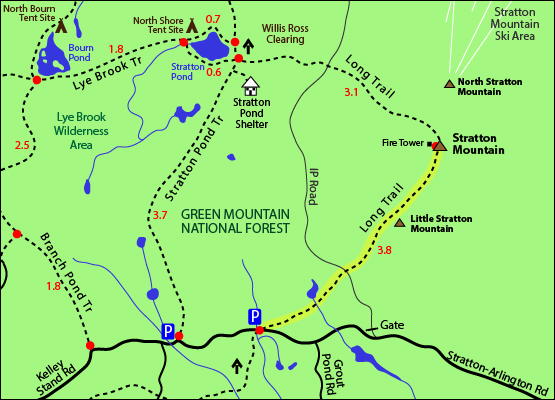
The map below shows how to get to the summit of Stratton Mountain from Stratton-Arlington Road.
From the Long Trail / Appalachian Trail parking area on Stratton-Arlington Road, hike up the Long Trail / Appalachian Trail for 3.8 miles until you reach the summit of Stratton Mountain. You will pass a small caretaker cabin right before the actual summit which has a fire tower. This trail is relatively easy and only has roughly 1,700 feet of elevation gain.
To get back to the parking area, go back the same way you came up.
Click to download PDF Trail Map of Stratton Mountain
|
| |
|
| |
| Stratton Mountain, View Photos |
Top |
|
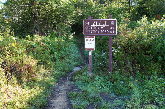
Beginning of the hike on the AT / LT. Taken on 9/18/14.
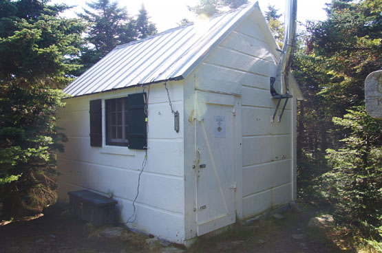
Caretaker's cabin near the summit of Stratton Mountain. Taken on 9/18/14.
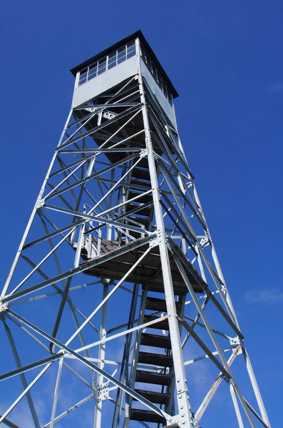
Summit tower on Stratton Mountain. Taken on 9/18/14.
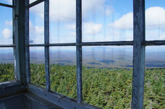
Views from the summit of Stratton Mountain's fire tower. Taken on 9/18/14.
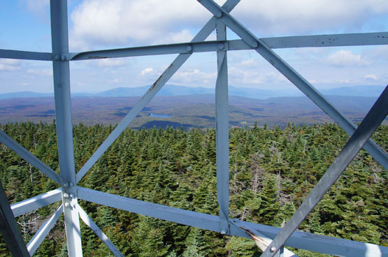
Views from the summit of Stratton Mountain's fire tower. Taken on 9/18/14.
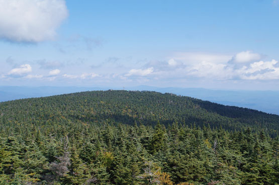
Views from the summit of Stratton Mountain's fire tower looking at North Stratton Mountain. Taken on 9/18/14.
|
| Stratton Mountain, Driving Directions |
Top |
If you have a GPS, you can enter 1280 Stratton-Arlington Road in Stratton, Vermont. This is a rough estimate of where the traillhead starts. Coming from Route 100 West, or Wardsboro, Vermont, the traillhead will be on the right side of the road after you pass Grout Pond Road on the left and the Kelley Stand Traillhead.
|
|
On this page: Information | Trail maps | View Photos | Driving Directions | Top
|
|
|
|
|
|
|
|
|
|
|
|
|
| |
| |
|
| New Hampshire 4,000 Footers |
Vermont + Maine 4,000 Footers |
Other Hiking Lists / Patches |
New England Mountain Ranges |
Stay Involved in New England |
New Hampshire
Mount Adams
Mount Bond
Bondcliff
Mount Bond, West Peak
Mount Cabot
Cannon Mountain
Mount Carrigain
Carter Dome
Carter, Middle
Carter, South
Mount Eisenhower
Mount Field
Mount Flume
Mount Galehead
Mount Garfield
Mount Hale
Mount Hancock
Mount Hancock, South Peak
Mount Isolation
Mount Jackson
Mount Jefferson
Mount Kinsman, North Peak
Mount Kinsman, South Peak
Mount Lafayette
Mount Liberty
Mount Lincoln
Mount Madison
Mount Monroe
Mount Moosilauke
Mount Moriah
Mount Osceola
Mount Osceola, East Peak
Owl's Head
Mount Passaconway
Mount Pierce
Mount Tecumseh
Mount Tom
Mount Tripyramid, Middle Peak
Mount Tripyramid, North Peak
Mount Twin, North Peak
Mount Twin, South Peak
Mount Washington
Mount Waumbek
Mount Whiteface
Mount Wildcat, A Peak
Mount Wildcat, D Peak
Mount Willey
Zealand Mountain |
Vermont
Mount Abraham
Camel's Hump
Mount Ellen
Killington Peak
Mount Mansfield
Maine
Mount Abraham
Mount Bigelow, Avery Peak
Mount Bigelow, West Peak
Crocker Mountain
Crocker Mountain, South
Mount Katahdin, Baxter Peak
Mount Katahdin, Hamlin Peak
North Brother Mountain
Old Speck Mountain
Mount Redington
Saddleback Mountain
Saddleback Mountain, The Horn
Spaulding Mountain
Sugarloaf Mountain |
NH 4,000 footers
NH 4,000 footers in Winter
New England 4,000 footers
NE 4,000 footers in Winter
NH Hundred Highest
New England Fifty Finest
52 With a view
Trailwrights 72 summit club
New England Hundred highest
NE Hundred highest in Winter
Northeast 111
48x12 "The Grid"
Red Lining
Belknap Range
LRCT / Castle in the Clouds
NH Fire Tower Quest
Hike by - Alphabetically
Hike by - Elevation
Hike by - Prominence
Hike by - Mountain Range |
Ranges in New Hampshire
View all NH mountain ranges
Baldface-Royce Range
Carter-Moriah Range
Dartmouth Range
Franconia Range
Kinsman Range
Mahoosuc
Range
Ossipee Mountains
Northern Ranges
Pemigewasset Wilderness
Pilot Range
Pliny Range
Presidential Range
Sandwich Range
Twin Range
Wapack Range
Western White Mountains
Willey Range
Ranges in Maine
View all ME mountain ranges
Baxter State Park
High Peaks
Bigelow Range
Eastern White Mountains
Ranges in Vermont
Green Mountains
Other VT mountain ranges |
NH Waterfalls
NH AMC Huts
Hiker's store |
New England 4,000 Footers | NH 4,000 Footers | VT 4,000 Footers | ME 4,000 Footers | Hiking Lists & Patches | Hiker's Store | Contact by email
© www.4000footers.com 2015. All rights reserved. We are not affiliated with the AMC or the AMC Four Thousand Footer Club |
|
|